Sasso Morelli geodata
Sasso Morelli (Emilia-Romagna) is a populated place; located in Italy in Europe/Rome (GMT+2) time zone. With population of 928 people, there are 6992 cities with bigger population in this country. Compared to other cities in Italy, 50.2% of cities are located further ↑North; 52.3% of cities are located further ←West and 87% of cities have higher elevation than Sasso Morelli. Note1


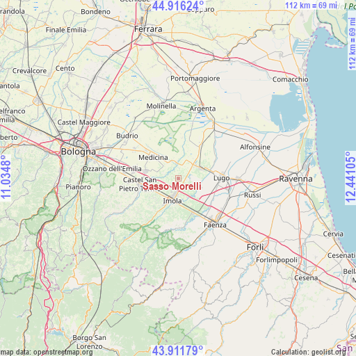
Sasso Morelli GPS coordinates[2]
44° 24' 58.212" North, 11° 44' 16.512" East
| Map corner | latitude | longitude |
|---|---|---|
| Upper-left | 44.91624°, | 11.0348° |
| Center: | 44.41617°, | 11.73792° |
| Lower-right: | 43.91179°, | 12.44105° |
| Map W x H: | 111.7×111.7 km | = 69.4×69.4mi |
| max Lat: | 47.04031° ⇑50.2% North |
| Sasso Morelli: | 44.41617° |
| min Lat: | ⇓49.8% South 35.50142° |
| min Long | Sasso Morelli | max Long |
| 6.69888° | 11.73792° | 18.48682° |
| W 52.3%⇐ | ⇒47.7% E |
Elevation
Elevation of Sasso Morelli is 25 m = 82 ft, and this is 281.7 m = 924 ft below average elevation for this country.
| Max E: |
2085 m = 6841 ft | 87% |
| Avg. | 306.7 m = 1006 ft | |
| Sasso Morelli | 25 m = 82 ft | |
Min E: |
-4 m = -13 ft | 13% |
See also: Italy elevation on elevation.city.
Geographical zone
Sasso Morelli is located in North temperate zone (between Tropic of Cancer and the Arctic Circle). Distance of this Northern Tropic circle is 2332.7 km =1449.5 mi to South.| Distance of | km | miles | from Sasso Morelli |
|---|---|---|---|
| North Pole | 5068.4 | 3149.4 | to North |
| Arctic Circle | 2462.6 | 1530.2 | to North |
| Tropic Cancer | 2332.7 | 1449.5 | to South |
| Equator | 4938.6 | 3068.7 | to South |


Nearby cities:
15 places around Sasso Morelli: (largest is in red/bold)
• Bagnara di Romagna
7.7 km =4.8 mi,  112°
112°
• Bubano
3.5 km =2.2 mi,  94°
94°
• Castel Guelfo di Bologna
5.2 km =3.2 mi,  289°
289°
• Dozza
10.1 km =6.3 mi,  233°
233°
• Ganzanigo
9.5 km =5.9 mi,  317°
317°
• Imola
6.6 km =4.1 mi,  197°
197°
• Massa Lombarda
7.4 km =4.6 mi,  62°
62°
• Medicina-Buda
10.5 km =6.5 mi,  311°
311°
• Mordano
5.9 km =3.7 mi, 111°
• San Prospero
6.5 km =4 mi,  152°
152°
• Sant'Agata sul Santerno
10.2 km =6.3 mi,  72°
72°
• Sesto Imolese
4.9 km =3 mi,  351°
351°
• Solarolo
10.7 km =6.6 mi,  126°
126°
• Toscanella
8.7 km =5.4 mi,  244°
244°
• Villa San Martino
10.3 km =6.4 mi, 90°
Sources, notices
• [Note1] Compared only with cities in Italy existing in our database
• [Src1] Map data: © OpenStreetMap contributors (CC-BY-SA)
• [Src2] Other city data from geonames.org with taken over terms of usage.
• [Src3] Geographical zone / Annual Mean Temperature by Robert A. Rohde @ Wikipedia
