Solarolo geodata
Solarolo (Emilia-Romagna) is a seat of a third-order administrative division; located in Italy in Europe/Rome (GMT+2) time zone. With population of 3,045 people, there are 3000 cities with bigger population in this country. Compared to other cities in Italy, 51.1% of cities are located further ↑North; 53.8% of cities are located further ←West and 86.7% of cities have higher elevation than Solarolo. Note1


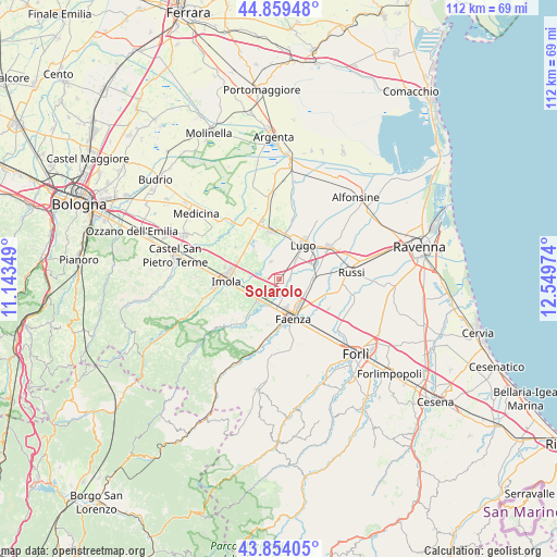
Solarolo GPS coordinates[2]
44° 21' 32.112" North, 11° 50' 47.796" East
| Map corner | latitude | longitude |
|---|---|---|
| Upper-left | 44.85948°, | 11.14349° |
| Center: | 44.35892°, | 11.84661° |
| Lower-right: | 43.85405°, | 12.54974° |
| Map W x H: | 111.8×111.8 km | = 69.5×69.5mi |
| max Lat: | 47.04031° ⇑51.1% North |
| Solarolo: | 44.35892° |
| min Lat: | ⇓48.9% South 35.50142° |
| min Long | Solarolo | max Long |
| 6.69888° | 11.84661° | 18.48682° |
| W 53.8%⇐ | ⇒46.2% E |
Elevation
Elevation of Solarolo is 26 m = 85 ft, and this is 280.7 m = 921 ft below average elevation for this country.
| Max E: |
2085 m = 6841 ft | 86.7% |
| Avg. | 306.7 m = 1006 ft | |
| Solarolo | 26 m = 85 ft | |
Min E: |
-4 m = -13 ft | 13.3% |
See also: Italy elevation on elevation.city.
Geographical zone
Solarolo is located in North temperate zone (between Tropic of Cancer and the Arctic Circle). Distance of this Northern Tropic circle is 2326.3 km =1445.5 mi to South.| Distance of | km | miles | from Solarolo |
|---|---|---|---|
| North Pole | 5074.8 | 3153.3 | to North |
| Arctic Circle | 2468.9 | 1534.1 | to North |
| Tropic Cancer | 2326.3 | 1445.5 | to South |
| Equator | 4932.2 | 3064.7 | to South |


Nearby cities:
15 places around Solarolo: (largest is in red/bold)
• Bagnara di Romagna
3.7 km =2.3 mi,  335°
335°
• Barbiano
4.6 km =2.9 mi,  42°
42°
• Bubano
7.9 km =4.9 mi,  319°
319°
• Castel Bolognese
5.8 km =3.6 mi,  221°
221°
• Cotignola
7.9 km =4.9 mi,  67°
67°
• Faenza
8.1 km =5 mi,  161°
161°
• Granarolo
7 km =4.3 mi,  90°
90°
• Imola
10.6 km =6.6 mi,  270°
270°
• Lugo
8.6 km =5.3 mi, 36°
• Massa Lombarda
10 km =6.2 mi,  348°
348°
• Mordano
5.2 km =3.2 mi, 323°
• San Prospero
5.7 km =3.5 mi,  276°
276°
• Sant'Agata sul Santerno
9.5 km =5.9 mi,  6°
6°
• Sasso Morelli
10.7 km =6.6 mi,  306°
306°
• Villa San Martino
6.6 km =4.1 mi, 14°
Sources, notices
• [Note1] Compared only with cities in Italy existing in our database
• [Src1] Map data: © OpenStreetMap contributors (CC-BY-SA)
• [Src2] Other city data from geonames.org with taken over terms of usage.
• [Src3] Geographical zone / Annual Mean Temperature by Robert A. Rohde @ Wikipedia
