Sabbionara geodata
Sabbionara (Trentino-Alto Adige) is a populated place; located in Italy in Europe/Rome (GMT+2) time zone. With population of 1,376 people, there are 5421 cities with bigger population in this country. Compared to other cities in Italy, 83.2% of cities are located further ↓South; 57.8% of cities are located further →East and 60.7% of cities have higher elevation than Sabbionara. Note1
Administrative division(s):
- Level 1: Trentino-Alto Adige
- Level 2: Provincia autonoma di Trento
- Level 3: Avio


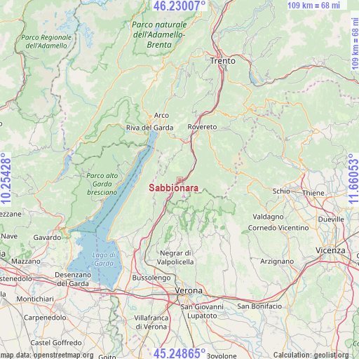
Sabbionara GPS coordinates[2]
45° 44' 29.472" North, 10° 57' 26.64" East
| Map corner | latitude | longitude |
|---|---|---|
| Upper-left | 46.23007°, | 10.25428° |
| Center: | 45.74152°, | 10.9574° |
| Lower-right: | 45.24865°, | 11.66053° |
| Map W x H: | 109.1×109.1 km | = 67.8×67.8mi |
| max Lat: | 47.04031° ⇑16.8% North |
| Sabbionara: | 45.74152° |
| min Lat: | ⇓83.2% South 35.50142° |
| min Long | Sabbionara | max Long |
| 6.69888° | 10.9574° | 18.48682° |
| W 42.2%⇐ | ⇒57.8% E |
Elevation
Elevation of Sabbionara is 158 m = 518 ft, and this is 148.7 m = 488 ft below average elevation for this country.
| Max E: |
2085 m = 6841 ft | 60.7% |
| Avg. | 306.7 m = 1006 ft | |
| Sabbionara | 158 m = 518 ft | |
Min E: |
-4 m = -13 ft | 39.3% |
See also: Italy elevation on elevation.city.
Geographical zone
Sabbionara is located in North temperate zone (between Tropic of Cancer and the Arctic Circle). Distance of this North polar circle is 2315.2 km =1438.6 mi to North.| Distance of | km | miles | from Sabbionara |
|---|---|---|---|
| North Pole | 4921.1 | 3057.8 | to North |
| Arctic Circle | 2315.2 | 1438.6 | to North |
| Tropic Cancer | 2480.1 | 1541.1 | to South |
| Equator | 5086 | 3160.3 | to South |


Nearby cities:
15 places around Sabbionara: (largest is in red/bold)
• Ala
4.2 km =2.6 mi,  59°
59°
• Avio
1.6 km =1 mi,  238°
238°
• Brentino Belluno
10.6 km =6.6 mi,  207°
207°
• Brentonico
8.6 km =5.3 mi,  358°
358°
• Chizzola
8.7 km =5.4 mi,  26°
26°
• Crosano
8.8 km =5.5 mi,  7°
7°
• Erbezzo
11.8 km =7.3 mi,  163°
163°
• Ferrara di Monte Baldo
10.7 km =6.6 mi,  225°
225°
• Malcesine
11.8 km =7.3 mi,  280°
280°
• Marco
11.9 km =7.4 mi,  19°
19°
• Mori
12.4 km =7.7 mi, 8°
• Pilcante
4.7 km =2.9 mi,  45°
45°
• Rivalta
10.6 km =6.6 mi, 207°
• Santa Margherita
8.2 km =5.1 mi,  40°
40°
• Serravalle
8.8 km =5.5 mi, 30°
Sources, notices
• [Note1] Compared only with cities in Italy existing in our database
• [Src1] Map data: © OpenStreetMap contributors (CC-BY-SA)
• [Src2] Other city data from geonames.org with taken over terms of usage.
• [Src3] Geographical zone / Annual Mean Temperature by Robert A. Rohde @ Wikipedia
