Ala geodata
Ala (Trentino-Alto Adige) is a seat of a third-order administrative division; located in Italy in Europe/Rome (GMT+2) time zone. With population of 5,331 people, there are 1832 cities with bigger population in this country. Compared to other cities in Italy, 84.1% of cities are located further ↓South; 57.3% of cities are located further →East and 59% of cities have higher elevation than Ala. Note1
Administrative division(s):
- Level 1: Trentino-Alto Adige
- Level 2: Provincia autonoma di Trento
- Level 3: Ala


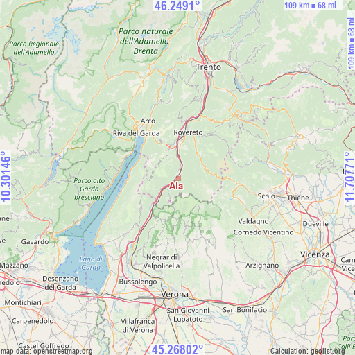
Ala GPS coordinates[2]
45° 45' 38.592" North, 11° 0' 16.488" East
| Map corner | latitude | longitude |
|---|---|---|
| Upper-left | 46.2491°, | 10.30146° |
| Center: | 45.76072°, | 11.00458° |
| Lower-right: | 45.26802°, | 11.70771° |
| Map W x H: | 109.1×109.1 km | = 67.8×67.8mi |
| max Lat: | 47.04031° ⇑15.9% North |
| Ala: | 45.76072° |
| min Lat: | ⇓84.1% South 35.50142° |
| min Long | Ala | max Long |
| 6.69888° | 11.00458° | 18.48682° |
| W 42.7%⇐ | ⇒57.3% E |
Elevation
Elevation of Ala is 171 m = 561 ft, and this is 135.7 m = 445 ft below average elevation for this country.
| Max E: |
2085 m = 6841 ft | 59% |
| Avg. | 306.7 m = 1006 ft | |
| Ala | 171 m = 561 ft | |
Min E: |
-4 m = -13 ft | 41% |
See also: Italy elevation on elevation.city.
Geographical zone
Ala is located in North temperate zone (between Tropic of Cancer and the Arctic Circle). Distance of this North polar circle is 2313.1 km =1437.3 mi to North.| Distance of | km | miles | from Ala |
|---|---|---|---|
| North Pole | 4918.9 | 3056.5 | to North |
| Arctic Circle | 2313.1 | 1437.3 | to North |
| Tropic Cancer | 2482.2 | 1542.4 | to South |
| Equator | 5088.1 | 3161.6 | to South |


Nearby cities:
15 places around Ala: (largest is in red/bold)
• Avio
5.9 km =3.7 mi,  239°
239°
• Brentonico
7.5 km =4.7 mi,  329°
329°
• Chizzola
5.7 km =3.5 mi,  2°
2°
• Crosano
7 km =4.3 mi,  339°
339°
• Erbezzo
13.5 km =8.4 mi,  181°
181°
• Isera
14.1 km =8.8 mi, 1°
• Marco
9.1 km =5.7 mi, 2°
• Mori
10.3 km =6.4 mi,  349°
349°
• Moscheri
13.2 km =8.2 mi,  24°
24°
• Pilcante
1.2 km =0.7 mi, 344°
• Sabbionara
4.2 km =2.6 mi, 239°
• Santa Margherita
4.4 km =2.7 mi, 21°
• Serravalle
5.6 km =3.5 mi,  8°
8°
• Trambileno
13.2 km =8.2 mi, 23°
• Vallarsa
9.1 km =5.7 mi,  74°
74°
Sources, notices
• [Note1] Compared only with cities in Italy existing in our database
• [Src1] Map data: © OpenStreetMap contributors (CC-BY-SA)
• [Src2] Other city data from geonames.org with taken over terms of usage.
• [Src3] Geographical zone / Annual Mean Temperature by Robert A. Rohde @ Wikipedia
