Pilcante geodata
Pilcante (Trentino-Alto Adige) is a populated place; located in Italy in Europe/Rome (GMT+2) time zone. With population of 616 people, there are 8872 cities with bigger population in this country. Compared to other cities in Italy, 84.5% of cities are located further ↓South; 57.3% of cities are located further →East and 59% of cities have higher elevation than Pilcante. Note1
Administrative division(s):
- Level 1: Trentino-Alto Adige
- Level 2: Provincia autonoma di Trento
- Level 3: Ala


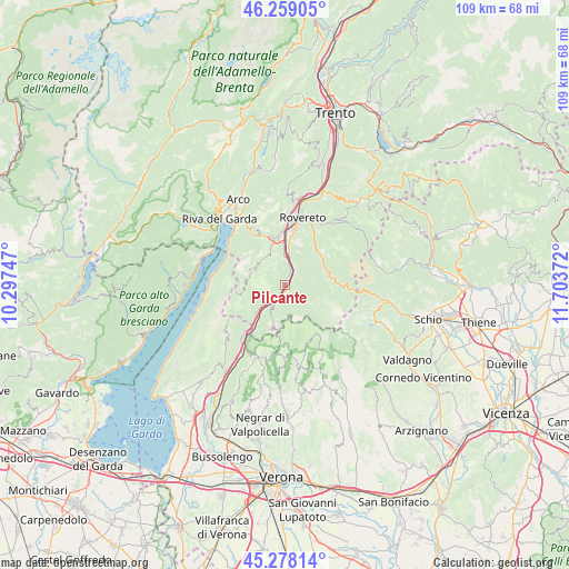
Pilcante GPS coordinates[2]
45° 46' 14.7" North, 11° 0' 2.124" East
| Map corner | latitude | longitude |
|---|---|---|
| Upper-left | 46.25905°, | 10.29747° |
| Center: | 45.77075°, | 11.00059° |
| Lower-right: | 45.27814°, | 11.70372° |
| Map W x H: | 109.1×109.1 km | = 67.8×67.8mi |
| max Lat: | 47.04031° ⇑15.5% North |
| Pilcante: | 45.77075° |
| min Lat: | ⇓84.5% South 35.50142° |
| min Long | Pilcante | max Long |
| 6.69888° | 11.00059° | 18.48682° |
| W 42.7%⇐ | ⇒57.3% E |
Elevation
Elevation of Pilcante is 171 m = 561 ft, and this is 135.7 m = 445 ft below average elevation for this country.
| Max E: |
2085 m = 6841 ft | 59% |
| Avg. | 306.7 m = 1006 ft | |
| Pilcante | 171 m = 561 ft | |
Min E: |
-4 m = -13 ft | 41% |
See also: Italy elevation on elevation.city.
Geographical zone
Pilcante is located in North temperate zone (between Tropic of Cancer and the Arctic Circle). Distance of this North polar circle is 2311.9 km =1436.5 mi to North.| Distance of | km | miles | from Pilcante |
|---|---|---|---|
| North Pole | 4917.8 | 3055.8 | to North |
| Arctic Circle | 2311.9 | 1436.5 | to North |
| Tropic Cancer | 2483.3 | 1543.1 | to South |
| Equator | 5089.2 | 3162.3 | to South |


Nearby cities:
15 places around Pilcante: (largest is in red/bold)
• Ala
1.2 km =0.7 mi,  164°
164°
• Avio
6.3 km =3.9 mi,  229°
229°
• Brentonico
6.4 km =4 mi,  326°
326°
• Chizzola
4.6 km =2.9 mi,  6°
6°
• Crosano
5.9 km =3.7 mi,  338°
338°
• Isera
13 km =8.1 mi,  2°
2°
• Marco
8 km =5 mi, 4°
• Mori
9.2 km =5.7 mi,  350°
350°
• Moscheri
12.3 km =7.6 mi,  27°
27°
• Rovereto
13.7 km =8.5 mi, 13°
• Sabbionara
4.7 km =2.9 mi, 225°
• Santa Margherita
3.6 km =2.2 mi, 33°
• Serravalle
4.5 km =2.8 mi, 14°
• Trambileno
12.3 km =7.6 mi, 27°
• Vallarsa
9.2 km =5.7 mi,  81°
81°
Sources, notices
• [Note1] Compared only with cities in Italy existing in our database
• [Src1] Map data: © OpenStreetMap contributors (CC-BY-SA)
• [Src2] Other city data from geonames.org with taken over terms of usage.
• [Src3] Geographical zone / Annual Mean Temperature by Robert A. Rohde @ Wikipedia
