Argine geodata
Argine (Emilia-Romagna) is a populated place; located in Italy in Europe/Rome (GMT+2) time zone. With population of 1,146 people, there are 6123 cities with bigger population in this country. Compared to other cities in Italy, 55.7% of cities are located further ↓South; 61.5% of cities are located further →East and 85.6% of cities have higher elevation than Argine. Note1
Administrative division(s):
- Level 1: Emilia-Romagna
- Level 2: Provincia di Reggio Emilia
- Level 3: Cadelbosco di Sopra


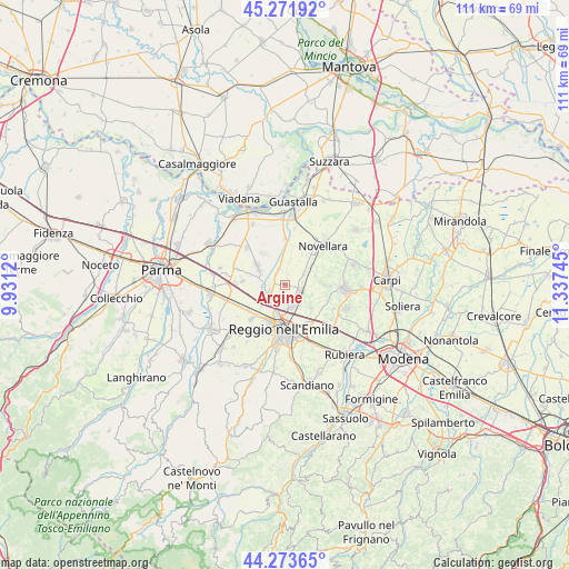
Argine GPS coordinates[2]
44° 46' 29.784" North, 10° 38' 3.552" East
| Map corner | latitude | longitude |
|---|---|---|
| Upper-left | 45.27192°, | 9.9312° |
| Center: | 44.77494°, | 10.63432° |
| Lower-right: | 44.27365°, | 11.33745° |
| Map W x H: | 111×111 km | = 69×69mi |
| max Lat: | 47.04031° ⇑44.3% North |
| Argine: | 44.77494° |
| min Lat: | ⇓55.7% South 35.50142° |
| min Long | Argine | max Long |
| 6.69888° | 10.63432° | 18.48682° |
| W 38.5%⇐ | ⇒61.5% E |
Elevation
Elevation of Argine is 29 m = 95 ft, and this is 277.7 m = 911 ft below average elevation for this country.
| Max E: |
2085 m = 6841 ft | 85.6% |
| Avg. | 306.7 m = 1006 ft | |
| Argine | 29 m = 95 ft | |
Min E: |
-4 m = -13 ft | 14.4% |
See also: Italy elevation on elevation.city.
Geographical zone
Argine is located in North temperate zone (between Tropic of Cancer and the Arctic Circle). Distance of this Northern Tropic circle is 2372.6 km =1474.3 mi to South.| Distance of | km | miles | from Argine |
|---|---|---|---|
| North Pole | 5028.6 | 3124.6 | to North |
| Arctic Circle | 2422.7 | 1505.4 | to North |
| Tropic Cancer | 2372.6 | 1474.3 | to South |
| Equator | 4978.5 | 3093.5 | to South |


Nearby cities:
15 places around Argine: (largest is in red/bold)
• Bagnolo in Piano
3.3 km =2.1 mi,  110°
110°
• Budrio
8.8 km =5.5 mi, 107°
• Cadelbosco di Sopra
3 km =1.9 mi,  249°
249°
• Cadelbosco di Sotto
3.3 km =2.1 mi,  333°
333°
• Campegine
8.4 km =5.2 mi,  274°
274°
• Canolo
9.4 km =5.8 mi,  75°
75°
• Case Cocconi
8.9 km =5.5 mi,  280°
280°
• Castello di Pratofontana
4.9 km =3 mi,  143°
143°
• Castelnovo di Sotto
6.8 km =4.2 mi,  308°
308°
• Fosdondo
7.9 km =4.9 mi,  90°
90°
• Massenzatico
6.7 km =4.2 mi,  131°
131°
• Meletole
9.2 km =5.7 mi, 333°
• Reggio nell'Emilia
8.5 km =5.3 mi,  181°
181°
• Roncocesi
6 km =3.7 mi,  227°
227°
• Santa Vittoria
8.9 km =5.5 mi,  359°
359°
Sources, notices
• [Note1] Compared only with cities in Italy existing in our database
• [Src1] Map data: © OpenStreetMap contributors (CC-BY-SA)
• [Src2] Other city data from geonames.org with taken over terms of usage.
• [Src3] Geographical zone / Annual Mean Temperature by Robert A. Rohde @ Wikipedia
