Meletole geodata
Meletole (Emilia-Romagna) is a populated place; located in Italy in Europe/Rome (GMT+2) time zone. With population of 591 people, there are 9082 cities with bigger population in this country. Compared to other cities in Italy, 57.1% of cities are located further ↓South; 62% of cities are located further →East and 89% of cities have higher elevation than Meletole. Note1
Administrative division(s):
- Level 1: Emilia-Romagna
- Level 2: Provincia di Reggio Emilia
- Level 3: Castelnovo di Sotto


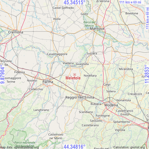
Meletole GPS coordinates[2]
44° 50' 55.716" North, 10° 34' 55.812" East
| Map corner | latitude | longitude |
|---|---|---|
| Upper-left | 45.34515°, | 9.87904° |
| Center: | 44.84881°, | 10.58217° |
| Lower-right: | 44.34816°, | 11.2853° |
| Map W x H: | 110.9×110.9 km | = 68.9×68.9mi |
| max Lat: | 47.04031° ⇑42.9% North |
| Meletole: | 44.84881° |
| min Lat: | ⇓57.1% South 35.50142° |
| min Long | Meletole | max Long |
| 6.69888° | 10.58217° | 18.48682° |
| W 38%⇐ | ⇒62% E |
Elevation
Elevation of Meletole is 20 m = 66 ft, and this is 286.7 m = 941 ft below average elevation for this country.
| Max E: |
2085 m = 6841 ft | 89% |
| Avg. | 306.7 m = 1006 ft | |
| Meletole | 20 m = 66 ft | |
Min E: |
-4 m = -13 ft | 11% |
See also: Italy elevation on elevation.city.
Geographical zone
Meletole is located in North temperate zone (between Tropic of Cancer and the Arctic Circle). Distance of this Northern Tropic circle is 2380.8 km =1479.4 mi to South.| Distance of | km | miles | from Meletole |
|---|---|---|---|
| North Pole | 5020.3 | 3119.5 | to North |
| Arctic Circle | 2414.5 | 1500.3 | to North |
| Tropic Cancer | 2380.8 | 1479.4 | to South |
| Equator | 4986.7 | 3098.6 | to South |


Nearby cities:
15 places around Meletole: (largest is in red/bold)
• Argine
9.2 km =5.7 mi,  153°
153°
• Boretto
6.3 km =3.9 mi,  337°
337°
• Brescello
7.5 km =4.7 mi,  313°
313°
• Cadelbosco di Sopra
9.3 km =5.8 mi,  171°
171°
• Cadelbosco di Sotto
5.9 km =3.7 mi, 153°
• Campegine
8.7 km =5.4 mi,  209°
209°
• Case Cocconi
8 km =5 mi, 214°
• Castelnovo di Sotto
4.2 km =2.6 mi,  196°
196°
• Gualtieri
6.5 km =4 mi,  34°
34°
• Guastalla
9.4 km =5.8 mi,  41°
41°
• Lentigione-Sorbolo a Mane
8 km =5 mi,  284°
284°
• Pieve Saliceto
5.6 km =3.5 mi,  16°
16°
• Pomponesco
9.2 km =5.7 mi,  5°
5°
• Poviglio
3.5 km =2.2 mi,  257°
257°
• Santa Vittoria
4.1 km =2.5 mi,  80°
80°
Sources, notices
• [Note1] Compared only with cities in Italy existing in our database
• [Src1] Map data: © OpenStreetMap contributors (CC-BY-SA)
• [Src2] Other city data from geonames.org with taken over terms of usage.
• [Src3] Geographical zone / Annual Mean Temperature by Robert A. Rohde @ Wikipedia
