Castelnovo di Sotto geodata
Castelnovo di Sotto (Emilia-Romagna) is a seat of a third-order administrative division; located in Italy in Europe/Rome (GMT+2) time zone. With population of 7,401 people, there are 1314 cities with bigger population in this country. Compared to other cities in Italy, 56.4% of cities are located further ↓South; 62.1% of cities are located further →East and 86.1% of cities have higher elevation than Castelnovo di Sotto. Note1
Administrative division(s):
- Level 1: Emilia-Romagna
- Level 2: Provincia di Reggio Emilia
- Level 3: Castelnovo di Sotto


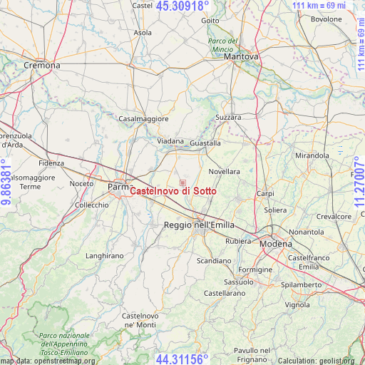
Castelnovo di Sotto GPS coordinates[2]
44° 48' 45.108" North, 10° 34' 0.984" East
| Map corner | latitude | longitude |
|---|---|---|
| Upper-left | 45.30918°, | 9.86381° |
| Center: | 44.81253°, | 10.56694° |
| Lower-right: | 44.31156°, | 11.27007° |
| Map W x H: | 110.9×110.9 km | = 68.9×68.9mi |
| max Lat: | 47.04031° ⇑43.6% North |
| Castelnovo di Sotto: | 44.81253° |
| min Lat: | ⇓56.4% South 35.50142° |
| min Long | Castelnovo di S | max Long |
| 6.69888° | 10.56694° | 18.48682° |
| W 37.9%⇐ | ⇒62.1% E |
Elevation
Elevation of Castelnovo di Sotto is 28 m = 92 ft, and this is 278.7 m = 914 ft below average elevation for this country.
| Max E: |
2085 m = 6841 ft | 86.1% |
| Avg. | 306.7 m = 1006 ft | |
| Castelnovo di Sotto | 28 m = 92 ft | |
Min E: |
-4 m = -13 ft | 13.9% |
See also: Italy elevation on elevation.city.
Geographical zone
Castelnovo di Sotto is located in North temperate zone (between Tropic of Cancer and the Arctic Circle). Distance of this Northern Tropic circle is 2376.8 km =1476.9 mi to South.| Distance of | km | miles | from Castelnovo di Sotto |
|---|---|---|---|
| North Pole | 5024.4 | 3122 | to North |
| Arctic Circle | 2418.5 | 1502.8 | to North |
| Tropic Cancer | 2376.8 | 1476.9 | to South |
| Equator | 4982.7 | 3096.1 | to South |


Nearby cities:
15 places around Castelnovo di Sotto: (largest is in red/bold)
• Argine
6.8 km =4.2 mi,  128°
128°
• Cadelbosco di Sopra
5.8 km =3.6 mi,  154°
154°
• Cadelbosco di Sotto
4 km =2.5 mi,  107°
107°
• Cadè-Gaida
9.2 km =5.7 mi,  206°
206°
• Calerno
9.5 km =5.9 mi,  222°
222°
• Campegine
4.7 km =2.9 mi, 220°
• Caprara
6 km =3.7 mi,  226°
226°
• Case Cocconi
4.3 km =2.7 mi, 233°
• Lentigione-Sorbolo a Mane
8.9 km =5.5 mi,  312°
312°
• Meletole
4.2 km =2.6 mi,  16°
16°
• Poviglio
4 km =2.5 mi,  326°
326°
• Praticello
7.5 km =4.7 mi,  263°
263°
• Praticello di Gattatico
7.3 km =4.5 mi, 263°
• Roncocesi
8.3 km =5.2 mi,  173°
173°
• Santa Vittoria
7 km =4.3 mi,  48°
48°
Sources, notices
• [Note1] Compared only with cities in Italy existing in our database
• [Src1] Map data: © OpenStreetMap contributors (CC-BY-SA)
• [Src2] Other city data from geonames.org with taken over terms of usage.
• [Src3] Geographical zone / Annual Mean Temperature by Robert A. Rohde @ Wikipedia
