Montoro geodata
Montoro (The Marches) is a populated place; located in Italy in Europe/Rome (GMT+2) time zone. With population of 551 people, there are 9440 cities with bigger population in this country. Compared to other cities in Italy, 60.2% of cities are located further ↑North; 72.5% of cities are located further ←West and 57.5% of cities have higher elevation than Montoro. Note1


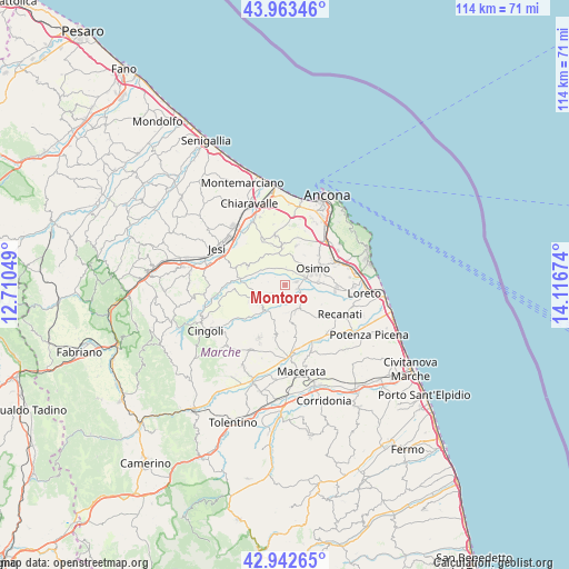
Montoro GPS coordinates[2]
43° 27' 18.756" North, 13° 24' 48.996" East
| Map corner | latitude | longitude |
|---|---|---|
| Upper-left | 43.96346°, | 12.71049° |
| Center: | 43.45521°, | 13.41361° |
| Lower-right: | 42.94265°, | 14.11674° |
| Map W x H: | 113.5×113.5 km | = 70.5×70.5mi |
| max Lat: | 47.04031° ⇑60.2% North |
| Montoro: | 43.45521° |
| min Lat: | ⇓39.8% South 35.50142° |
| min Long | Montoro | max Long |
| 6.69888° | 13.41361° | 18.48682° |
| W 72.5%⇐ | ⇒27.5% E |
Elevation
Elevation of Montoro is 184 m = 604 ft, and this is 122.7 m = 403 ft below average elevation for this country.
| Max E: |
2085 m = 6841 ft | 57.5% |
| Avg. | 306.7 m = 1006 ft | |
| Montoro | 184 m = 604 ft | |
Min E: |
-4 m = -13 ft | 42.5% |
See also: Italy elevation on elevation.city.
Geographical zone
Montoro is located in North temperate zone (between Tropic of Cancer and the Arctic Circle). Distance of this Northern Tropic circle is 2225.8 km =1383 mi to South.| Distance of | km | miles | from Montoro |
|---|---|---|---|
| North Pole | 5175.3 | 3215.8 | to North |
| Arctic Circle | 2569.4 | 1596.6 | to North |
| Tropic Cancer | 2225.8 | 1383 | to South |
| Equator | 4831.8 | 3002.3 | to South |


Nearby cities:
15 places around Montoro: (largest is in red/bold)
• Abbadia
10.6 km =6.6 mi,  69°
69°
• Agugliano
10.1 km =6.3 mi,  347°
347°
• Campocavallo
6.7 km =4.2 mi,  84°
84°
• Castelfidardo
11.1 km =6.9 mi,  87°
87°
• Filottrano
5.5 km =3.4 mi,  246°
246°
• Montecassiano
10.2 km =6.3 mi,  168°
168°
• Montefano
5.4 km =3.4 mi,  159°
159°
• Offagna
8.2 km =5.1 mi,  15°
15°
• Osimo
6.5 km =4 mi,  58°
58°
• Padiglione
4.2 km =2.6 mi, 68°
• Polverigi
8.5 km =5.3 mi,  343°
343°
• Ponte dell'Aspio
10.8 km =6.7 mi,  39°
39°
• San Biagio
9.5 km =5.9 mi, 44°
• San Sabino
8.2 km =5.1 mi, 75°
• Santa Maria Nuova
8.3 km =5.2 mi,  299°
299°
Sources, notices
• [Note1] Compared only with cities in Italy existing in our database
• [Src1] Map data: © OpenStreetMap contributors (CC-BY-SA)
• [Src2] Other city data from geonames.org with taken over terms of usage.
• [Src3] Geographical zone / Annual Mean Temperature by Robert A. Rohde @ Wikipedia
