Montalto geodata
Montalto (Tuscany) is a populated place; located in Italy in Europe/Rome (GMT+2) time zone. With population of 1,057 people, there are 6451 cities with bigger population in this country. Compared to other cities in Italy, 59.8% of cities are located further ↑North; 51.3% of cities are located further ←West and 51.9% of cities have lower elevation than Montalto. Note1
Administrative division(s):
- Level 1: Tuscany
- Level 2: Province of Arezzo
- Level 3: Laterina Pergine Valdarno


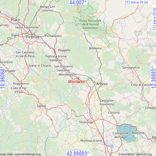
Montalto GPS coordinates[2]
43° 29' 56.832" North, 11° 39' 49.68" East
| Map corner | latitude | longitude |
|---|---|---|
| Upper-left | 44.007°, | 10.96068° |
| Center: | 43.49912°, | 11.6638° |
| Lower-right: | 42.98693°, | 12.36693° |
| Map W x H: | 113.4×113.4 km | = 70.5×70.5mi |
| max Lat: | 47.04031° ⇑59.8% North |
| Montalto: | 43.49912° |
| min Lat: | ⇓40.2% South 35.50142° |
| min Long | Montalto | max Long |
| 6.69888° | 11.6638° | 18.48682° |
| W 51.3%⇐ | ⇒48.7% E |
Elevation
Elevation of Montalto is 246 m = 807 ft, and this is 60.7 m = 199 ft below average elevation for this country.
| Max E: |
2085 m = 6841 ft | 48.1% |
| Avg. | 306.7 m = 1006 ft | |
| Montalto | 246 m = 807 ft | |
Min E: |
-4 m = -13 ft | 51.9% |
See also: Italy elevation on elevation.city.
Geographical zone
Montalto is located in North temperate zone (between Tropic of Cancer and the Arctic Circle). Distance of this Northern Tropic circle is 2230.7 km =1386.1 mi to South.| Distance of | km | miles | from Montalto |
|---|---|---|---|
| North Pole | 5170.4 | 3212.7 | to North |
| Arctic Circle | 2564.5 | 1593.5 | to North |
| Tropic Cancer | 2230.7 | 1386.1 | to South |
| Equator | 4836.6 | 3005.3 | to South |


Nearby cities:
15 places around Montalto: (largest is in red/bold)
• Ambra
10.6 km =6.6 mi,  207°
207°
• Badia Agnano
7.1 km =4.4 mi,  189°
189°
• Bucine
4.7 km =2.9 mi,  238°
238°
• Castiglion Fibocchi
8.5 km =5.3 mi,  68°
68°
• Cavi-Casalone
4.2 km =2.6 mi,  121°
121°
• Civitella in Val di Chiana
10.3 km =6.4 mi,  152°
152°
• Laterina
4.3 km =2.7 mi,  85°
85°
• Loro Ciuffenna
10.3 km =6.4 mi,  344°
344°
• Montevarchi
7.9 km =4.9 mi,  291°
291°
• Penna
8.7 km =5.4 mi,  330°
330°
• Pergine Valdarno
3.7 km =2.3 mi, 151°
• Ponticino
4.7 km =2.9 mi, 116°
• San Giustino Valdarno
6.8 km =4.2 mi,  29°
29°
• Terranuova Bracciolini
8.8 km =5.5 mi,  310°
310°
• Torre
8.3 km =5.2 mi,  254°
254°
Sources, notices
• [Note1] Compared only with cities in Italy existing in our database
• [Src1] Map data: © OpenStreetMap contributors (CC-BY-SA)
• [Src2] Other city data from geonames.org with taken over terms of usage.
• [Src3] Geographical zone / Annual Mean Temperature by Robert A. Rohde @ Wikipedia
