Badia Agnano geodata
Badia Agnano (Tuscany) is a populated place; located in Italy in Europe/Rome (GMT+2) time zone. With population of 825 people, there are 7527 cities with bigger population in this country. Compared to other cities in Italy, 60.4% of cities are located further ↑North; 51.2% of cities are located further ←West and 55.9% of cities have lower elevation than Badia Agnano. Note1


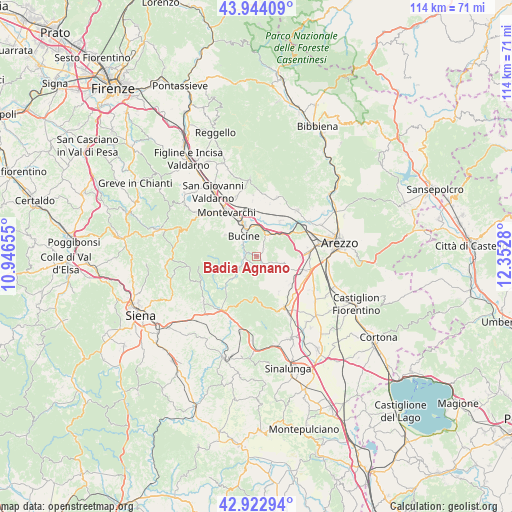
Badia Agnano GPS coordinates[2]
43° 26' 8.412" North, 11° 38' 58.812" East
| Map corner | latitude | longitude |
|---|---|---|
| Upper-left | 43.94409°, | 10.94655° |
| Center: | 43.43567°, | 11.64967° |
| Lower-right: | 42.92294°, | 12.3528° |
| Map W x H: | 113.5×113.5 km | = 70.5×70.5mi |
| max Lat: | 47.04031° ⇑60.4% North |
| Badia Agnano: | 43.43567° |
| min Lat: | ⇓39.6% South 35.50142° |
| min Long | Badia Agnano | max Long |
| 6.69888° | 11.64967° | 18.48682° |
| W 51.2%⇐ | ⇒48.8% E |
Elevation
Elevation of Badia Agnano is 271 m = 889 ft, and this is 35.7 m = 117 ft below average elevation for this country.
| Max E: |
2085 m = 6841 ft | 44.1% |
| Avg. | 306.7 m = 1006 ft | |
| Badia Agnano | 271 m = 889 ft | |
Min E: |
-4 m = -13 ft | 55.9% |
See also: Italy elevation on elevation.city.
Geographical zone
Badia Agnano is located in North temperate zone (between Tropic of Cancer and the Arctic Circle). Distance of this Northern Tropic circle is 2223.7 km =1381.7 mi to South.| Distance of | km | miles | from Badia Agnano |
|---|---|---|---|
| North Pole | 5177.5 | 3217.1 | to North |
| Arctic Circle | 2571.6 | 1597.9 | to North |
| Tropic Cancer | 2223.7 | 1381.7 | to South |
| Equator | 4829.6 | 3001 | to South |


Nearby cities:
15 places around Badia Agnano: (largest is in red/bold)
• Ambra
4.4 km =2.7 mi,  238°
238°
• Badia al Pino
10.5 km =6.5 mi,  109°
109°
• Battifolle-Ruscello-Poggiola
12.2 km =7.6 mi,  82°
82°
• Bucine
5.4 km =3.4 mi,  327°
327°
• Cavi-Casalone
6.8 km =4.2 mi,  44°
44°
• Ciggiano
9.4 km =5.8 mi,  146°
146°
• Civitella in Val di Chiana
6.3 km =3.9 mi, 109°
• Laterina
9.2 km =5.7 mi, 36°
• Montalto
7.1 km =4.4 mi,  9°
9°
• Montevarchi
11.7 km =7.3 mi, 327°
• Pergine Valdarno
4.8 km =3 mi, 36°
• Ponticino
7.3 km =4.5 mi,  47°
47°
• Tegoleto
11.9 km =7.4 mi, 112°
• Torre
8.4 km =5.2 mi,  305°
305°
• Viciomaggio
10 km =6.2 mi,  92°
92°
Sources, notices
• [Note1] Compared only with cities in Italy existing in our database
• [Src1] Map data: © OpenStreetMap contributors (CC-BY-SA)
• [Src2] Other city data from geonames.org with taken over terms of usage.
• [Src3] Geographical zone / Annual Mean Temperature by Robert A. Rohde @ Wikipedia
