Ambra geodata
Ambra (Tuscany) is a populated place; located in Italy in Europe/Rome (GMT+2) time zone. With population of 1,247 people, there are 5800 cities with bigger population in this country. Compared to other cities in Italy, 60.5% of cities are located further ↑North; 50.6% of cities are located further ←West and 53.2% of cities have lower elevation than Ambra. Note1


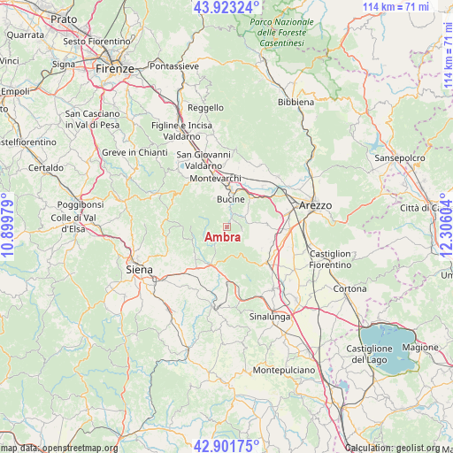
Ambra GPS coordinates[2]
43° 24' 52.74" North, 11° 36' 10.476" East
| Map corner | latitude | longitude |
|---|---|---|
| Upper-left | 43.92324°, | 10.89979° |
| Center: | 43.41465°, | 11.60291° |
| Lower-right: | 42.90175°, | 12.30604° |
| Map W x H: | 113.6×113.6 km | = 70.6×70.6mi |
| max Lat: | 47.04031° ⇑60.5% North |
| Ambra: | 43.41465° |
| min Lat: | ⇓39.5% South 35.50142° |
| min Long | Ambra | max Long |
| 6.69888° | 11.60291° | 18.48682° |
| W 50.6%⇐ | ⇒49.4% E |
Elevation
Elevation of Ambra is 254 m = 833 ft, and this is 52.7 m = 173 ft below average elevation for this country.
| Max E: |
2085 m = 6841 ft | 46.8% |
| Avg. | 306.7 m = 1006 ft | |
| Ambra | 254 m = 833 ft | |
Min E: |
-4 m = -13 ft | 53.2% |
See also: Italy elevation on elevation.city.
Geographical zone
Ambra is located in North temperate zone (between Tropic of Cancer and the Arctic Circle). Distance of this Northern Tropic circle is 2221.3 km =1380.3 mi to South.| Distance of | km | miles | from Ambra |
|---|---|---|---|
| North Pole | 5179.8 | 3218.6 | to North |
| Arctic Circle | 2573.9 | 1599.3 | to North |
| Tropic Cancer | 2221.3 | 1380.3 | to South |
| Equator | 4827.3 | 2999.5 | to South |


Nearby cities:
15 places around Ambra: (largest is in red/bold)
• Badia Agnano
4.4 km =2.7 mi,  58°
58°
• Badia al Pino
13.7 km =8.5 mi,  94°
94°
• Bucine
7 km =4.3 mi,  7°
7°
• Castelnuovo Berardenga
11.3 km =7 mi,  227°
227°
• Cavi-Casalone
11.2 km =7 mi,  49°
49°
• Ciggiano
10.5 km =6.5 mi,  121°
121°
• Civitella in Val di Chiana
9.7 km =6 mi, 88°
• Laterina
13.4 km =8.3 mi,  43°
43°
• Montalto
10.6 km =6.6 mi,  27°
27°
• Monte San Savino
13.6 km =8.5 mi,  132°
132°
• Montevarchi
12.5 km =7.8 mi,  348°
348°
• Pergine Valdarno
9.1 km =5.7 mi, 47°
• Ponticino
11.7 km =7.3 mi, 51°
• Rapolano Terme
13.3 km =8.3 mi,  180°
180°
• Torre
7.9 km =4.9 mi,  336°
336°
Sources, notices
• [Note1] Compared only with cities in Italy existing in our database
• [Src1] Map data: © OpenStreetMap contributors (CC-BY-SA)
• [Src2] Other city data from geonames.org with taken over terms of usage.
• [Src3] Geographical zone / Annual Mean Temperature by Robert A. Rohde @ Wikipedia
