Basella geodata
Basella (Lombardy) is a populated place; located in Italy in Europe/Rome (GMT+2) time zone. With population of 990 people, there are 6711 cities with bigger population in this country. Compared to other cities in Italy, 77.7% of cities are located further ↓South; 70.5% of cities are located further →East and 57.3% of cities have higher elevation than Basella. Note1


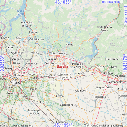
Basella GPS coordinates[2]
45° 36' 50.148" North, 9° 43' 43.176" East
| Map corner | latitude | longitude |
|---|---|---|
| Upper-left | 46.1036°, | 9.02553° |
| Center: | 45.61393°, | 9.72866° |
| Lower-right: | 45.11994°, | 10.43179° |
| Map W x H: | 109.4×109.4 km | = 68×68mi |
| max Lat: | 47.04031° ⇑22.3% North |
| Basella: | 45.61393° |
| min Lat: | ⇓77.7% South 35.50142° |
| min Long | Basella | max Long |
| 6.69888° | 9.72866° | 18.48682° |
| W 29.5%⇐ | ⇒70.5% E |
Elevation
Elevation of Basella is 185 m = 607 ft, and this is 121.7 m = 399 ft below average elevation for this country.
| Max E: |
2085 m = 6841 ft | 57.3% |
| Avg. | 306.7 m = 1006 ft | |
| Basella | 185 m = 607 ft | |
Min E: |
-4 m = -13 ft | 42.7% |
See also: Italy elevation on elevation.city.
Geographical zone
Basella is located in North temperate zone (between Tropic of Cancer and the Arctic Circle). Distance of this North polar circle is 2329.4 km =1447.4 mi to North.| Distance of | km | miles | from Basella |
|---|---|---|---|
| North Pole | 4935.3 | 3066.7 | to North |
| Arctic Circle | 2329.4 | 1447.4 | to North |
| Tropic Cancer | 2465.9 | 1532.2 | to South |
| Equator | 5071.8 | 3151.5 | to South |


Nearby cities:
15 places around Basella: (largest is in red/bold)
• Azzano San Paolo
6.5 km =4 mi,  318°
318°
• Bagnatica
6.6 km =4.1 mi,  37°
37°
• Bolgare
7 km =4.3 mi,  72°
72°
• Brusaporto
6.9 km =4.3 mi,  21°
21°
• Calcinate
5.5 km =3.4 mi,  83°
83°
• Cavernago
3.1 km =1.9 mi, 66°
• Cologno al Serio
4.5 km =2.8 mi,  200°
200°
• Comun Nuovo
5.3 km =3.3 mi,  280°
280°
• Ghisalba
3.2 km =2 mi,  135°
135°
• Grassobbio
4.8 km =3 mi,  357°
357°
• Martinengo
5.5 km =3.4 mi,  146°
146°
• Mornico al Serio
6.8 km =4.2 mi,  111°
111°
• Spirano
5.9 km =3.7 mi,  232°
232°
• Urgnano
3.1 km =1.9 mi,  238°
238°
• Zanica
4.5 km =2.8 mi,  311°
311°
Sources, notices
• [Note1] Compared only with cities in Italy existing in our database
• [Src1] Map data: © OpenStreetMap contributors (CC-BY-SA)
• [Src2] Other city data from geonames.org with taken over terms of usage.
• [Src3] Geographical zone / Annual Mean Temperature by Robert A. Rohde @ Wikipedia
