Ghisalba geodata
Ghisalba (Lombardy) is a seat of a third-order administrative division; located in Italy in Europe/Rome (GMT+2) time zone. With population of 5,786 people, there are 1695 cities with bigger population in this country. Compared to other cities in Italy, 76.8% of cities are located further ↓South; 70.2% of cities are located further →East and 59.6% of cities have higher elevation than Ghisalba. Note1


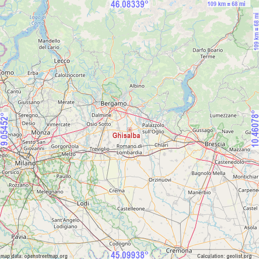
Ghisalba GPS coordinates[2]
45° 35' 36.744" North, 9° 45' 27.54" East
| Map corner | latitude | longitude |
|---|---|---|
| Upper-left | 46.08339°, | 9.05452° |
| Center: | 45.59354°, | 9.75765° |
| Lower-right: | 45.09938°, | 10.46078° |
| Map W x H: | 109.4×109.4 km | = 68×68mi |
| max Lat: | 47.04031° ⇑23.2% North |
| Ghisalba: | 45.59354° |
| min Lat: | ⇓76.8% South 35.50142° |
| min Long | Ghisalba | max Long |
| 6.69888° | 9.75765° | 18.48682° |
| W 29.8%⇐ | ⇒70.2% E |
Elevation
Elevation of Ghisalba is 166 m = 545 ft, and this is 140.7 m = 462 ft below average elevation for this country.
| Max E: |
2085 m = 6841 ft | 59.6% |
| Avg. | 306.7 m = 1006 ft | |
| Ghisalba | 166 m = 545 ft | |
Min E: |
-4 m = -13 ft | 40.4% |
See also: Italy elevation on elevation.city.
Geographical zone
Ghisalba is located in North temperate zone (between Tropic of Cancer and the Arctic Circle). Distance of this North polar circle is 2331.6 km =1448.8 mi to North.| Distance of | km | miles | from Ghisalba |
|---|---|---|---|
| North Pole | 4937.5 | 3068 | to North |
| Arctic Circle | 2331.6 | 1448.8 | to North |
| Tropic Cancer | 2463.6 | 1530.8 | to South |
| Equator | 5069.5 | 3150 | to South |


Nearby cities:
15 places around Ghisalba: (largest is in red/bold)
• Bagnatica
7.7 km =4.8 mi,  13°
13°
• Basella
3.2 km =2 mi,  315°
315°
• Bolgare
6.2 km =3.9 mi,  45°
45°
• Calcinate
4.3 km =2.7 mi, 47°
• Cavernago
3.6 km =2.2 mi, 9°
• Cividate al Piano
7.1 km =4.4 mi,  127°
127°
• Cologno al Serio
4.3 km =2.7 mi,  242°
242°
• Cortenuova
6.5 km =4 mi,  158°
158°
• Cortenuova di Sopra
5.8 km =3.6 mi, 161°
• Grassobbio
7.5 km =4.7 mi,  340°
340°
• Martinengo
2.5 km =1.6 mi, 162°
• Mornico al Serio
4 km =2.5 mi,  93°
93°
• Palosco
6.2 km =3.9 mi, 94°
• Spirano
7.1 km =4.4 mi,  259°
259°
• Urgnano
4.9 km =3 mi,  277°
277°
Sources, notices
• [Note1] Compared only with cities in Italy existing in our database
• [Src1] Map data: © OpenStreetMap contributors (CC-BY-SA)
• [Src2] Other city data from geonames.org with taken over terms of usage.
• [Src3] Geographical zone / Annual Mean Temperature by Robert A. Rohde @ Wikipedia
