Urgnano geodata
Urgnano (Lombardy) is a seat of a third-order administrative division; located in Italy in Europe/Rome (GMT+2) time zone. With population of 7,914 people, there are 1232 cities with bigger population in this country. Compared to other cities in Italy, 77% of cities are located further ↓South; 70.8% of cities are located further →East and 58.8% of cities have higher elevation than Urgnano. Note1


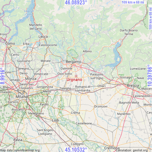
Urgnano GPS coordinates[2]
45° 35' 57.948" North, 9° 41' 41.028" East
| Map corner | latitude | longitude |
|---|---|---|
| Upper-left | 46.08923°, | 8.9916° |
| Center: | 45.59943°, | 9.69473° |
| Lower-right: | 45.10532°, | 10.39786° |
| Map W x H: | 109.4×109.4 km | = 68×68mi |
| max Lat: | 47.04031° ⇑23% North |
| Urgnano: | 45.59943° |
| min Lat: | ⇓77% South 35.50142° |
| min Long | Urgnano | max Long |
| 6.69888° | 9.69473° | 18.48682° |
| W 29.2%⇐ | ⇒70.8% E |
Elevation
Elevation of Urgnano is 173 m = 568 ft, and this is 133.7 m = 439 ft below average elevation for this country.
| Max E: |
2085 m = 6841 ft | 58.8% |
| Avg. | 306.7 m = 1006 ft | |
| Urgnano | 173 m = 568 ft | |
Min E: |
-4 m = -13 ft | 41.2% |
See also: Italy elevation on elevation.city.
Geographical zone
Urgnano is located in North temperate zone (between Tropic of Cancer and the Arctic Circle). Distance of this North polar circle is 2331 km =1448.4 mi to North.| Distance of | km | miles | from Urgnano |
|---|---|---|---|
| North Pole | 4936.9 | 3067.6 | to North |
| Arctic Circle | 2331 | 1448.4 | to North |
| Tropic Cancer | 2464.3 | 1531.2 | to South |
| Equator | 5070.2 | 3150.5 | to South |


Nearby cities:
15 places around Urgnano: (largest is in red/bold)
• Arcene
6.7 km =4.2 mi,  248°
248°
• Basella
3.1 km =1.9 mi,  58°
58°
• Cavernago
6.2 km =3.9 mi, 62°
• Cologno al Serio
2.8 km =1.7 mi,  156°
156°
• Comun Nuovo
3.6 km =2.2 mi,  315°
315°
• Ghisalba
4.9 km =3 mi,  97°
97°
• Levate
6.2 km =3.9 mi,  297°
297°
• Lurano
5.7 km =3.5 mi,  228°
228°
• Martinengo
6.4 km =4 mi,  118°
118°
• Pognano
4.5 km =2.8 mi, 251°
• Spirano
2.9 km =1.8 mi, 225°
• Stezzano
6.5 km =4 mi,  329°
329°
• Verdellino
6.7 km =4.2 mi,  271°
271°
• Verdello
5.2 km =3.2 mi,  275°
275°
• Zanica
4.7 km =2.9 mi,  351°
351°
Sources, notices
• [Note1] Compared only with cities in Italy existing in our database
• [Src1] Map data: © OpenStreetMap contributors (CC-BY-SA)
• [Src2] Other city data from geonames.org with taken over terms of usage.
• [Src3] Geographical zone / Annual Mean Temperature by Robert A. Rohde @ Wikipedia
