Zanica geodata
Zanica (Lombardy) is a seat of a third-order administrative division; located in Italy in Europe/Rome (GMT+2) time zone. With population of 7,242 people, there are 1345 cities with bigger population in this country. Compared to other cities in Italy, 78.7% of cities are located further ↓South; 70.9% of cities are located further →East and 53.9% of cities have higher elevation than Zanica. Note1


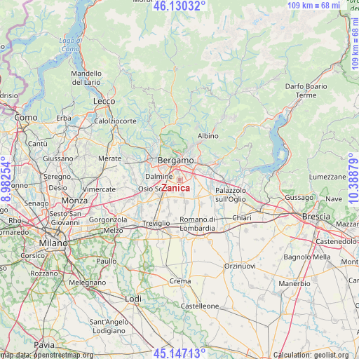
Zanica GPS coordinates[2]
45° 38' 27.168" North, 9° 41' 8.376" East
| Map corner | latitude | longitude |
|---|---|---|
| Upper-left | 46.13032°, | 8.98254° |
| Center: | 45.64088°, | 9.68566° |
| Lower-right: | 45.14713°, | 10.38879° |
| Map W x H: | 109.3×109.3 km | = 67.9×67.9mi |
| max Lat: | 47.04031° ⇑21.3% North |
| Zanica: | 45.64088° |
| min Lat: | ⇓78.7% South 35.50142° |
| min Long | Zanica | max Long |
| 6.69888° | 9.68566° | 18.48682° |
| W 29.1%⇐ | ⇒70.9% E |
Elevation
Elevation of Zanica is 210 m = 689 ft, and this is 96.7 m = 317 ft below average elevation for this country.
| Max E: |
2085 m = 6841 ft | 53.9% |
| Avg. | 306.7 m = 1006 ft | |
| Zanica | 210 m = 689 ft | |
Min E: |
-4 m = -13 ft | 46.1% |
See also: Italy elevation on elevation.city.
Geographical zone
Zanica is located in North temperate zone (between Tropic of Cancer and the Arctic Circle). Distance of this North polar circle is 2326.4 km =1445.6 mi to North.| Distance of | km | miles | from Zanica |
|---|---|---|---|
| North Pole | 4932.3 | 3064.8 | to North |
| Arctic Circle | 2326.4 | 1445.6 | to North |
| Tropic Cancer | 2468.9 | 1534.1 | to South |
| Equator | 5074.8 | 3153.3 | to South |


Nearby cities:
15 places around Zanica: (largest is in red/bold)
• Azzano San Paolo
2.1 km =1.3 mi,  332°
332°
• Basella
4.5 km =2.8 mi,  131°
131°
• Bergamo
6.3 km =3.9 mi,  346°
346°
• Brusaporto
6.7 km =4.2 mi,  59°
59°
• Cavernago
6.4 km =4 mi,  105°
105°
• Comun Nuovo
2.7 km =1.7 mi,  222°
222°
• Dalmine
6.2 km =3.9 mi,  278°
278°
• Grassobbio
3.6 km =2.2 mi, 60°
• Lallio
5 km =3.1 mi,  298°
298°
• Levate
5.1 km =3.2 mi,  249°
249°
• Orio al Serio
3.8 km =2.4 mi,  6°
6°
• Seriate
5.8 km =3.6 mi,  31°
31°
• Stezzano
2.8 km =1.7 mi,  290°
290°
• Urgnano
4.7 km =2.9 mi,  171°
171°
• Verdello
6.1 km =3.8 mi,  227°
227°
Sources, notices
• [Note1] Compared only with cities in Italy existing in our database
• [Src1] Map data: © OpenStreetMap contributors (CC-BY-SA)
• [Src2] Other city data from geonames.org with taken over terms of usage.
• [Src3] Geographical zone / Annual Mean Temperature by Robert A. Rohde @ Wikipedia
