Torrice geodata
Torrice (Latium) is a seat of a third-order administrative division; located in Italy in Europe/Rome (GMT+2) time zone. With population of 888 people, there are 7221 cities with bigger population in this country. Compared to other cities in Italy, 73.6% of cities are located further ↑North; 72.4% of cities are located further ←West and 58.2% of cities have lower elevation than Torrice. Note1


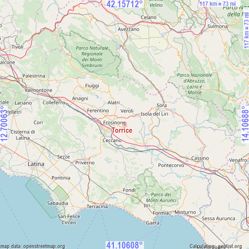
Torrice GPS coordinates[2]
41° 38' 1.464" North, 13° 24' 13.5" East
| Map corner | latitude | longitude |
|---|---|---|
| Upper-left | 42.15712°, | 12.70063° |
| Center: | 41.63374°, | 13.40375° |
| Lower-right: | 41.10608°, | 14.10688° |
| Map W x H: | 116.9×116.9 km | = 72.6×72.6mi |
| max Lat: | 47.04031° ⇑73.6% North |
| Torrice: | 41.63374° |
| min Lat: | ⇓26.4% South 35.50142° |
| min Long | Torrice | max Long |
| 6.69888° | 13.40375° | 18.48682° |
| W 72.4%⇐ | ⇒27.6% E |
Elevation
Elevation of Torrice is 287 m = 942 ft, and this is 19.7 m = 65 ft below average elevation for this country.
| Max E: |
2085 m = 6841 ft | 41.8% |
| Avg. | 306.7 m = 1006 ft | |
| Torrice | 287 m = 942 ft | |
Min E: |
-4 m = -13 ft | 58.2% |
See also: Italy elevation on elevation.city.
Geographical zone
Torrice is located in North temperate zone (between Tropic of Cancer and the Arctic Circle). Distance of this Northern Tropic circle is 2023.3 km =1257.2 mi to South.| Distance of | km | miles | from Torrice |
|---|---|---|---|
| North Pole | 5377.8 | 3341.6 | to North |
| Arctic Circle | 2771.9 | 1722.4 | to North |
| Tropic Cancer | 2023.3 | 1257.2 | to South |
| Equator | 4629.2 | 2876.5 | to South |


Nearby cities:
15 places around Torrice: (largest is in red/bold)
• Arillette
5.9 km =3.7 mi,  308°
308°
• Arnara
5.6 km =3.5 mi,  193°
193°
• Boville Ernica
5.8 km =3.6 mi,  80°
80°
• Brecciaro
5.8 km =3.6 mi,  92°
92°
• Casavitola
3.8 km =2.4 mi,  58°
58°
• Castelmassimo
3.9 km =2.4 mi,  330°
330°
• Colle Campano-Scrima
5.1 km =3.2 mi,  102°
102°
• Frosinone
5.2 km =3.2 mi,  277°
277°
• La Vittoria
4.7 km =2.9 mi,  22°
22°
• Mole Bisleti
5.8 km =3.6 mi,  336°
336°
• Ripi
2.8 km =1.7 mi,  142°
142°
• Rotabile
5.9 km =3.7 mi, 58°
• San Giuseppe le Prata-Cotropagno
4.9 km =3 mi,  353°
353°
• Sant'Angelo in Villa-Giglio
3.8 km =2.4 mi,  33°
33°
• Veroli
6.8 km =4.2 mi,  9°
9°
Sources, notices
• [Note1] Compared only with cities in Italy existing in our database
• [Src1] Map data: © OpenStreetMap contributors (CC-BY-SA)
• [Src2] Other city data from geonames.org with taken over terms of usage.
• [Src3] Geographical zone / Annual Mean Temperature by Robert A. Rohde @ Wikipedia
