Casavitola geodata
Casavitola (Latium) is a populated place; located in Italy in Europe/Rome (GMT+2) time zone. With population of 842 people, there are 7438 cities with bigger population in this country. Compared to other cities in Italy, 73.4% of cities are located further ↑North; 72.9% of cities are located further ←West and 51.8% of cities have higher elevation than Casavitola. Note1


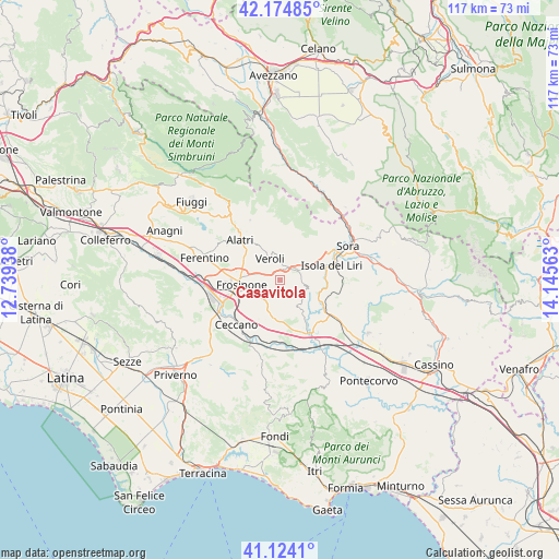
Casavitola GPS coordinates[2]
41° 39' 5.832" North, 13° 26' 33" East
| Map corner | latitude | longitude |
|---|---|---|
| Upper-left | 42.17485°, | 12.73938° |
| Center: | 41.65162°, | 13.4425° |
| Lower-right: | 41.1241°, | 14.14563° |
| Map W x H: | 116.8×116.8 km | = 72.6×72.6mi |
| max Lat: | 47.04031° ⇑73.4% North |
| Casavitola: | 41.65162° |
| min Lat: | ⇓26.6% South 35.50142° |
| min Long | Casavitola | max Long |
| 6.69888° | 13.4425° | 18.48682° |
| W 72.9%⇐ | ⇒27.1% E |
Elevation
Elevation of Casavitola is 223 m = 732 ft, and this is 83.7 m = 275 ft below average elevation for this country.
| Max E: |
2085 m = 6841 ft | 51.8% |
| Avg. | 306.7 m = 1006 ft | |
| Casavitola | 223 m = 732 ft | |
Min E: |
-4 m = -13 ft | 48.2% |
See also: Italy elevation on elevation.city.
Geographical zone
Casavitola is located in North temperate zone (between Tropic of Cancer and the Arctic Circle). Distance of this Northern Tropic circle is 2025.3 km =1258.5 mi to South.| Distance of | km | miles | from Casavitola |
|---|---|---|---|
| North Pole | 5375.8 | 3340.4 | to North |
| Arctic Circle | 2769.9 | 1721.1 | to North |
| Tropic Cancer | 2025.3 | 1258.5 | to South |
| Equator | 4631.2 | 2877.7 | to South |


Nearby cities:
15 places around Casavitola: (largest is in red/bold)
• Antica Colle Piscioso
3.4 km =2.1 mi,  70°
70°
• Boville Ernica
2.7 km =1.7 mi,  111°
111°
• Brecciaro
3.4 km =2.1 mi,  130°
130°
• Case Campoli-Panetta
3.4 km =2.1 mi,  45°
45°
• Castelmassimo
5.3 km =3.3 mi,  284°
284°
• Colle Campano-Scrima
3.6 km =2.2 mi,  150°
150°
• Colleberardi
4 km =2.5 mi,  12°
12°
• La Vittoria
2.7 km =1.7 mi,  328°
328°
• Monte San Giovanni Campano
5.8 km =3.6 mi,  99°
99°
• Ripi
4.5 km =2.8 mi,  200°
200°
• Rotabile
2.1 km =1.3 mi,  59°
59°
• San Giuseppe le Prata-Cotropagno
4.8 km =3 mi,  307°
307°
• Sant'Angelo in Villa-Giglio
1.6 km =1 mi,  315°
315°
• Torrice
3.8 km =2.4 mi,  238°
238°
• Veroli
5.2 km =3.2 mi,  335°
335°
Sources, notices
• [Note1] Compared only with cities in Italy existing in our database
• [Src1] Map data: © OpenStreetMap contributors (CC-BY-SA)
• [Src2] Other city data from geonames.org with taken over terms of usage.
• [Src3] Geographical zone / Annual Mean Temperature by Robert A. Rohde @ Wikipedia
