Vescovado geodata
Vescovado (Tuscany) is a seat of a third-order administrative division; located in Italy in Europe/Rome (GMT+2) time zone. With population of 821 people, there are 7544 cities with bigger population in this country. Compared to other cities in Italy, 62% of cities are located further ↑North; 52% of cities are located further →East and 58.7% of cities have lower elevation than Vescovado. Note1


Vescovado GPS coordinates[2]
43° 10' 10.308" North, 11° 23' 31.128" East
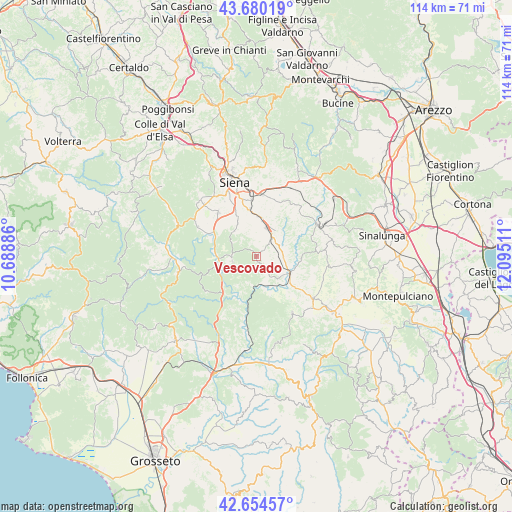
| Map corner | latitude | longitude |
|---|---|---|
| Upper-left | 43.68019°, | 10.68886° |
| Center: | 43.16953°, | 11.39198° |
| Lower-right: | 42.65457°, | 12.09511° |
| Map W x H: | 114×114 km | = 70.8×70.8mi |
| max Lat: | 47.04031° ⇑62% North |
| Vescovado: | 43.16953° |
| min Lat: | ⇓38% South 35.50142° |
| min Long | Vescovado | max Long |
| 6.69888° | 11.39198° | 18.48682° |
| W 48%⇐ | ⇒52% E |
Elevation
Elevation of Vescovado is 290 m = 951 ft, and this is 16.7 m = 55 ft below average elevation for this country.
| Max E: |
2085 m = 6841 ft | 41.3% |
| Avg. | 306.7 m = 1006 ft | |
| Vescovado | 290 m = 951 ft | |
Min E: |
-4 m = -13 ft | 58.7% |
See also: Italy elevation on elevation.city.
Geographical zone
Vescovado is located in North temperate zone (between Tropic of Cancer and the Arctic Circle). Distance of this Northern Tropic circle is 2194.1 km =1363.4 mi to South.| Distance of | km | miles | from Vescovado |
|---|---|---|---|
| North Pole | 5207.1 | 3235.5 | to North |
| Arctic Circle | 2601.2 | 1616.3 | to North |
| Tropic Cancer | 2194.1 | 1363.4 | to South |
| Equator | 4800 | 2982.6 | to South |


Nearby cities:
15 places around Vescovado: (largest is in red/bold)
• Arbia
13.9 km =8.6 mi,  5°
5°
• Asciano
15.8 km =9.8 mi,  63°
63°
• Buonconvento
8.5 km =5.3 mi,  118°
118°
• Casciano
5.4 km =3.4 mi,  263°
263°
• Isola D'Arbia
10 km =6.2 mi,  353°
353°
• Montalcino
15.1 km =9.4 mi,  148°
148°
• Monteroni d'Arbia
7.1 km =4.4 mi,  20°
20°
• Murlo
1 km =0.6 mi,  199°
199°
• Ponte A Tressa
9.1 km =5.7 mi,  1°
1°
• Rosia
16.2 km =10.1 mi,  301°
301°
• San Giovanni d'Asso
16.1 km =10 mi,  96°
96°
• Sant'Andrea A Montecchio
14.7 km =9.1 mi,  329°
329°
• Siena
17.3 km =10.7 mi,  343°
343°
• Taverne D'Arbia
13.9 km =8.6 mi, 0°
• Torrenieri
15.8 km =9.8 mi,  126°
126°
Sources, notices
• [Note1] Compared only with cities in Italy existing in our database
• [Src1] Map data: © OpenStreetMap contributors (CC-BY-SA)
• [Src2] Other city data from geonames.org with taken over terms of usage.
• [Src3] Geographical zone / Annual Mean Temperature by Robert A. Rohde @ Wikipedia
