Asciano geodata
Asciano (Tuscany) is a seat of a third-order administrative division; located in Italy in Europe/Rome (GMT+2) time zone. With population of 4,114 people, there are 2330 cities with bigger population in this country. Compared to other cities in Italy, 61.6% of cities are located further ↑North; 50.3% of cities are located further ←West and 52.7% of cities have higher elevation than Asciano. Note1


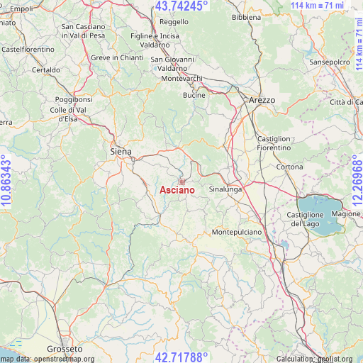
Asciano GPS coordinates[2]
43° 13' 56.352" North, 11° 33' 59.58" East
| Map corner | latitude | longitude |
|---|---|---|
| Upper-left | 43.74245°, | 10.86343° |
| Center: | 43.23232°, | 11.56655° |
| Lower-right: | 42.71788°, | 12.26968° |
| Map W x H: | 113.9×113.9 km | = 70.8×70.8mi |
| max Lat: | 47.04031° ⇑61.6% North |
| Asciano: | 43.23232° |
| min Lat: | ⇓38.4% South 35.50142° |
| min Long | Asciano | max Long |
| 6.69888° | 11.56655° | 18.48682° |
| W 50.3%⇐ | ⇒49.7% E |
Elevation
Elevation of Asciano is 218 m = 715 ft, and this is 88.7 m = 291 ft below average elevation for this country.
| Max E: |
2085 m = 6841 ft | 52.7% |
| Avg. | 306.7 m = 1006 ft | |
| Asciano | 218 m = 715 ft | |
Min E: |
-4 m = -13 ft | 47.3% |
See also: Italy elevation on elevation.city.
Geographical zone
Asciano is located in North temperate zone (between Tropic of Cancer and the Arctic Circle). Distance of this Northern Tropic circle is 2201.1 km =1367.7 mi to South.| Distance of | km | miles | from Asciano |
|---|---|---|---|
| North Pole | 5200.1 | 3231.2 | to North |
| Arctic Circle | 2594.2 | 1612 | to North |
| Tropic Cancer | 2201.1 | 1367.7 | to South |
| Equator | 4807 | 2986.9 | to South |


Nearby cities:
15 places around Asciano: (largest is in red/bold)
• Arbia
14.4 km =8.9 mi,  298°
298°
• Buonconvento
12.9 km =8 mi,  211°
211°
• Castelnuovo Berardenga
13.7 km =8.5 mi,  336°
336°
• Isola D'Arbia
15.5 km =9.6 mi,  280°
280°
• Lucignano
15.2 km =9.4 mi,  72°
72°
• Monteaperti
15.2 km =9.4 mi,  313°
313°
• Monteroni d'Arbia
11.7 km =7.3 mi,  268°
268°
• Ponte A Tressa
14 km =8.7 mi, 278°
• Rapolano Terme
7.6 km =4.7 mi,  22°
22°
• San Giovanni d'Asso
9 km =5.6 mi,  168°
168°
• Serre di Rapolano
4.9 km =3 mi,  56°
56°
• Sinalunga
14.6 km =9.1 mi,  97°
97°
• Taverne D'Arbia
15.5 km =9.6 mi, 296°
• Trequanda
9.6 km =6 mi,  121°
121°
• Vescovado
15.8 km =9.8 mi,  243°
243°
Sources, notices
• [Note1] Compared only with cities in Italy existing in our database
• [Src1] Map data: © OpenStreetMap contributors (CC-BY-SA)
• [Src2] Other city data from geonames.org with taken over terms of usage.
• [Src3] Geographical zone / Annual Mean Temperature by Robert A. Rohde @ Wikipedia
