Borgo Montello geodata
Borgo Montello (Latium) is a populated place; located in Italy in Europe/Rome (GMT+2) time zone. With population of 894 people, there are 7185 cities with bigger population in this country. Compared to other cities in Italy, 74.7% of cities are located further ↑North; 65.9% of cities are located further ←West and 87.4% of cities have higher elevation than Borgo Montello. Note1


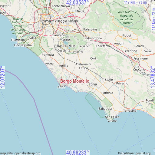
Borgo Montello GPS coordinates[2]
41° 30' 39.564" North, 12° 46' 30.684" East
| Map corner | latitude | longitude |
|---|---|---|
| Upper-left | 42.03537°, | 12.07207° |
| Center: | 41.51099°, | 12.77519° |
| Lower-right: | 40.98233°, | 13.47832° |
| Map W x H: | 117.1×117.1 km | = 72.8×72.8mi |
| max Lat: | 47.04031° ⇑74.7% North |
| Borgo Montello: | 41.51099° |
| min Lat: | ⇓25.3% South 35.50142° |
| min Long | Borgo Montello | max Long |
| 6.69888° | 12.77519° | 18.48682° |
| W 65.9%⇐ | ⇒34.1% E |
Elevation
Elevation of Borgo Montello is 24 m = 79 ft, and this is 282.7 m = 927 ft below average elevation for this country.
| Max E: |
2085 m = 6841 ft | 87.4% |
| Avg. | 306.7 m = 1006 ft | |
| Borgo Montello | 24 m = 79 ft | |
Min E: |
-4 m = -13 ft | 12.6% |
See also: Italy elevation on elevation.city.
Geographical zone
Borgo Montello is located in North temperate zone (between Tropic of Cancer and the Arctic Circle). Distance of this Northern Tropic circle is 2009.7 km =1248.8 mi to South.| Distance of | km | miles | from Borgo Montello |
|---|---|---|---|
| North Pole | 5391.5 | 3350.1 | to North |
| Arctic Circle | 2785.6 | 1730.9 | to North |
| Tropic Cancer | 2009.7 | 1248.8 | to South |
| Equator | 4615.6 | 2868 | to South |


Nearby cities:
15 places around Borgo Montello: (largest is in red/bold)
• Borgo Bainsizza
3.4 km =2.1 mi,  153°
153°
• Borgo Carso
9.8 km =6.1 mi,  74°
74°
• Borgo Flora
6.3 km =3.9 mi,  47°
47°
• Borgo Piave
8 km =5 mi,  113°
113°
• Borgo Podgora
6.6 km =4.1 mi,  86°
86°
• Borgo Sabotino-Foce Verde
11.6 km =7.2 mi,  155°
155°
• Borgo Santa Maria
5.8 km =3.6 mi, 161°
• Campoverde
4.5 km =2.8 mi,  313°
313°
• Chiesuola
9.9 km =6.2 mi, 94°
• Cisterna di Latina
9.9 km =6.2 mi,  26°
26°
• Crocefisso
6.6 km =4.1 mi,  138°
138°
• Farneto
8 km =5 mi,  133°
133°
• Genio Civile
8.1 km =5 mi,  300°
300°
• Latina
11.9 km =7.4 mi, 114°
• Nettuno
11 km =6.8 mi,  237°
237°
Sources, notices
• [Note1] Compared only with cities in Italy existing in our database
• [Src1] Map data: © OpenStreetMap contributors (CC-BY-SA)
• [Src2] Other city data from geonames.org with taken over terms of usage.
• [Src3] Geographical zone / Annual Mean Temperature by Robert A. Rohde @ Wikipedia
