Crocefisso geodata
Crocefisso (Latium) is a populated place; located in Italy in Europe/Rome (GMT+2) time zone. With population of 885 people, there are 7236 cities with bigger population in this country. Compared to other cities in Italy, 75.1% of cities are located further ↑North; 66.4% of cities are located further ←West and 87.8% of cities have higher elevation than Crocefisso. Note1


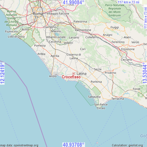
Crocefisso GPS coordinates[2]
41° 27' 57.96" North, 12° 49' 38.316" East
| Map corner | latitude | longitude |
|---|---|---|
| Upper-left | 41.99084°, | 12.12419° |
| Center: | 41.4661°, | 12.82731° |
| Lower-right: | 40.93708°, | 13.53044° |
| Map W x H: | 117.2×117.2 km | = 72.8×72.8mi |
| max Lat: | 47.04031° ⇑75.1% North |
| Crocefisso: | 41.4661° |
| min Lat: | ⇓24.9% South 35.50142° |
| min Long | Crocefisso | max Long |
| 6.69888° | 12.82731° | 18.48682° |
| W 66.4%⇐ | ⇒33.6% E |
Elevation
Elevation of Crocefisso is 23 m = 75 ft, and this is 283.7 m = 931 ft below average elevation for this country.
| Max E: |
2085 m = 6841 ft | 87.8% |
| Avg. | 306.7 m = 1006 ft | |
| Crocefisso | 23 m = 75 ft | |
Min E: |
-4 m = -13 ft | 12.2% |
See also: Italy elevation on elevation.city.
Geographical zone
Crocefisso is located in North temperate zone (between Tropic of Cancer and the Arctic Circle). Distance of this Northern Tropic circle is 2004.7 km =1245.7 mi to South.| Distance of | km | miles | from Crocefisso |
|---|---|---|---|
| North Pole | 5396.5 | 3353.2 | to North |
| Arctic Circle | 2790.6 | 1734 | to North |
| Tropic Cancer | 2004.7 | 1245.7 | to South |
| Equator | 4610.6 | 2864.9 | to South |


Nearby cities:
15 places around Crocefisso: (largest is in red/bold)
• Borgo Bainsizza
3.5 km =2.2 mi,  304°
304°
• Borgo Carso
9.2 km =5.7 mi,  33°
33°
• Borgo Flora
9.3 km =5.8 mi,  1°
1°
• Borgo Montello
6.6 km =4.1 mi,  318°
318°
• Borgo Piave
3.5 km =2.2 mi,  59°
59°
• Borgo Podgora
5.8 km =3.6 mi,  22°
22°
• Borgo Sabotino-Foce Verde
5.5 km =3.4 mi,  174°
174°
• Borgo Santa Maria
2.5 km =1.6 mi,  258°
258°
• Campoverde
11.1 km =6.9 mi, 316°
• Chiesuola
7 km =4.3 mi,  52°
52°
• Farneto
1.5 km =0.9 mi,  110°
110°
• Latina
6.4 km =4 mi,  89°
89°
• Latina Scalo
12.3 km =7.6 mi, 53°
• Prato di Coppola
7 km =4.3 mi,  140°
140°
• Scopeto Madonna Gulia
12.2 km =7.6 mi, 112°
Sources, notices
• [Note1] Compared only with cities in Italy existing in our database
• [Src1] Map data: © OpenStreetMap contributors (CC-BY-SA)
• [Src2] Other city data from geonames.org with taken over terms of usage.
• [Src3] Geographical zone / Annual Mean Temperature by Robert A. Rohde @ Wikipedia
