Gauro geodata
Gauro (Campania) is a populated place; located in Italy in Europe/Rome (GMT+2) time zone. With population of 807 people, there are 7612 cities with bigger population in this country. Compared to other cities in Italy, 82.3% of cities are located further ↑North; 86.9% of cities are located further ←West and 62.5% of cities have lower elevation than Gauro. Note1
Administrative division(s):
- Level 1: Campania
- Level 2: Provincia di Salerno
- Level 3: Montecorvino Rovella


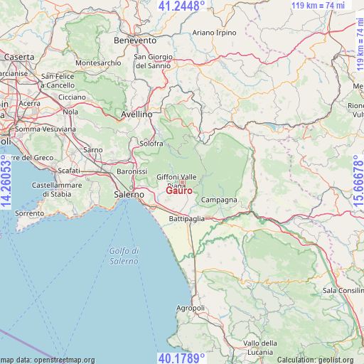
Gauro GPS coordinates[2]
40° 42' 50.328" North, 14° 57' 49.14" East
| Map corner | latitude | longitude |
|---|---|---|
| Upper-left | 41.2448°, | 14.26053° |
| Center: | 40.71398°, | 14.96365° |
| Lower-right: | 40.1789°, | 15.66678° |
| Map W x H: | 118.5×118.5 km | = 73.6×73.6mi |
| max Lat: | 47.04031° ⇑82.3% North |
| Gauro: | 40.71398° |
| min Lat: | ⇓17.7% South 35.50142° |
| min Long | Gauro | max Long |
| 6.69888° | 14.96365° | 18.48682° |
| W 86.9%⇐ | ⇒13.1% E |
Elevation
Elevation of Gauro is 319 m = 1047 ft, and this is 12.3 m = 40 ft above average elevation for this country.
| Max E: |
2085 m = 6841 ft | 37.5% |
| Gauro | 319 m 1047 ft | |
| Avg. | 306.7 m = 1006 ft | |
Min E: |
-4 m = -13 ft | 62.5% |
See also: Italy elevation on elevation.city.
Geographical zone
Gauro is located in North temperate zone (between Tropic of Cancer and the Arctic Circle). Distance of this Northern Tropic circle is 1921.1 km =1193.7 mi to South.| Distance of | km | miles | from Gauro |
|---|---|---|---|
| North Pole | 5480.1 | 3405.2 | to North |
| Arctic Circle | 2874.2 | 1785.9 | to North |
| Tropic Cancer | 1921.1 | 1193.7 | to South |
| Equator | 4527 | 2812.9 | to South |


Nearby cities:
15 places around Gauro: (largest is in red/bold)
• Capitignano
5 km =3.1 mi,  275°
275°
• Curti
5.4 km =3.4 mi,  319°
319°
• Faiano
7.7 km =4.8 mi,  222°
222°
• Giffoni Valle Piana
1.9 km =1.2 mi, 284°
• Macchia
6.8 km =4.2 mi,  169°
169°
• Malche-Santa Croce-Serroni
4.8 km =3 mi,  263°
263°
• Mercato
2 km =1.2 mi, 276°
• Montecorvino Pugliano
4.2 km =2.6 mi,  202°
202°
• Montecorvino Rovella
2.8 km =1.7 mi,  152°
152°
• Prepezzano
6.3 km =3.9 mi, 283°
• Pugliano
4.2 km =2.6 mi, 201°
• Salitto-Valle
6.6 km =4.1 mi,  131°
131°
• San Giovanni-Santa Caterina
4.1 km =2.5 mi, 315°
• Santa Tecla-Castelpagano
5.9 km =3.7 mi, 220°
• Sieti
6 km =3.7 mi,  301°
301°
Sources, notices
• [Note1] Compared only with cities in Italy existing in our database
• [Src1] Map data: © OpenStreetMap contributors (CC-BY-SA)
• [Src2] Other city data from geonames.org with taken over terms of usage.
• [Src3] Geographical zone / Annual Mean Temperature by Robert A. Rohde @ Wikipedia
