Trappolone geodata
Trappolone (Emilia-Romagna) is a populated place; located in Italy in Europe/Rome (GMT+2) time zone. With population of 772 people, there are 7806 cities with bigger population in this country. Compared to other cities in Italy, 50.3% of cities are located further ↓South; 52.4% of cities are located further →East and 68% of cities have higher elevation than Trappolone. Note1


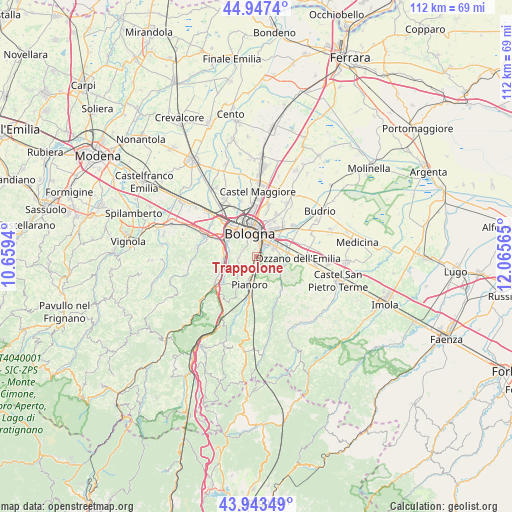
Trappolone GPS coordinates[2]
44° 26' 51.36" North, 11° 21' 45.072" East
| Map corner | latitude | longitude |
|---|---|---|
| Upper-left | 44.9474°, | 10.6594° |
| Center: | 44.4476°, | 11.36252° |
| Lower-right: | 43.94349°, | 12.06565° |
| Map W x H: | 111.6×111.6 km | = 69.3×69.3mi |
| max Lat: | 47.04031° ⇑49.7% North |
| Trappolone: | 44.4476° |
| min Lat: | ⇓50.3% South 35.50142° |
| min Long | Trappolone | max Long |
| 6.69888° | 11.36252° | 18.48682° |
| W 47.6%⇐ | ⇒52.4% E |
Elevation
Elevation of Trappolone is 109 m = 358 ft, and this is 197.7 m = 649 ft below average elevation for this country.
| Max E: |
2085 m = 6841 ft | 68% |
| Avg. | 306.7 m = 1006 ft | |
| Trappolone | 109 m = 358 ft | |
Min E: |
-4 m = -13 ft | 32% |
See also: Italy elevation on elevation.city.
Geographical zone
Trappolone is located in North temperate zone (between Tropic of Cancer and the Arctic Circle). Distance of this Northern Tropic circle is 2336.2 km =1451.6 mi to South.| Distance of | km | miles | from Trappolone |
|---|---|---|---|
| North Pole | 5065 | 3147.2 | to North |
| Arctic Circle | 2459.1 | 1528 | to North |
| Tropic Cancer | 2336.2 | 1451.6 | to South |
| Equator | 4942.1 | 3070.9 | to South |


Nearby cities:
15 places around Trappolone: (largest is in red/bold)
• Bologna
5.5 km =3.4 mi,  339°
339°
• Borgonuovo
7.4 km =4.6 mi,  259°
259°
• Casalecchio di Reno
7.6 km =4.7 mi,  294°
294°
• Maggio
11 km =6.8 mi,  96°
96°
• Martiri di Pizzocalvo
2.8 km =1.7 mi,  84°
84°
• Mercatale
8.2 km =5.1 mi,  139°
139°
• Ozzano dell'Emilia
9 km =5.6 mi,  92°
92°
• Pianoro
6.7 km =4.2 mi,  193°
193°
• Ponticella
1.5 km =0.9 mi,  58°
58°
• Pulce
3.9 km =2.4 mi, 87°
• Quarto Inferiore
10.2 km =6.3 mi,  24°
24°
• Rastignano-Carteria di Sesto
1.3 km =0.8 mi,  199°
199°
• San Lazzaro
4.5 km =2.8 mi, 55°
• Sasso Marconi
10.2 km =6.3 mi,  239°
239°
• Villanova
8 km =5 mi,  43°
43°
Sources, notices
• [Note1] Compared only with cities in Italy existing in our database
• [Src1] Map data: © OpenStreetMap contributors (CC-BY-SA)
• [Src2] Other city data from geonames.org with taken over terms of usage.
• [Src3] Geographical zone / Annual Mean Temperature by Robert A. Rohde @ Wikipedia
