Pianoro geodata
Pianoro (Emilia-Romagna) is a seat of a third-order administrative division; located in Italy in Europe/Rome (GMT+2) time zone. With population of 8,257 people, there are 1167 cities with bigger population in this country. Compared to other cities in Italy, 50.6% of cities are located further ↑North; 52.6% of cities are located further →East and 57.2% of cities have higher elevation than Pianoro. Note1


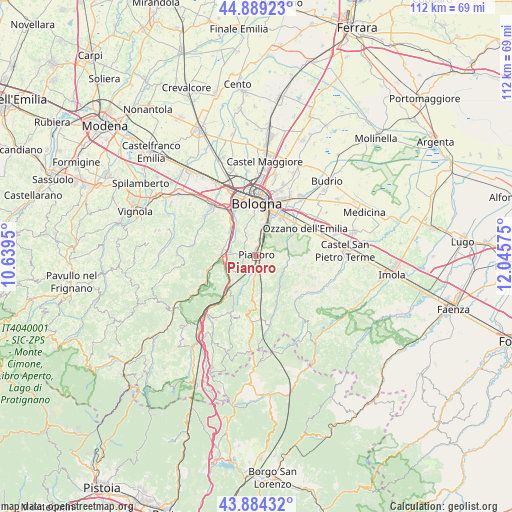
Pianoro GPS coordinates[2]
44° 23' 20.148" North, 11° 20' 33.432" East
| Map corner | latitude | longitude |
|---|---|---|
| Upper-left | 44.88923°, | 10.6395° |
| Center: | 44.38893°, | 11.34262° |
| Lower-right: | 43.88432°, | 12.04575° |
| Map W x H: | 111.7×111.7 km | = 69.4×69.4mi |
| max Lat: | 47.04031° ⇑50.6% North |
| Pianoro: | 44.38893° |
| min Lat: | ⇓49.4% South 35.50142° |
| min Long | Pianoro | max Long |
| 6.69888° | 11.34262° | 18.48682° |
| W 47.4%⇐ | ⇒52.6% E |
Elevation
Elevation of Pianoro is 186 m = 610 ft, and this is 120.7 m = 396 ft below average elevation for this country.
| Max E: |
2085 m = 6841 ft | 57.2% |
| Avg. | 306.7 m = 1006 ft | |
| Pianoro | 186 m = 610 ft | |
Min E: |
-4 m = -13 ft | 42.8% |
See also: Italy elevation on elevation.city.
Geographical zone
Pianoro is located in North temperate zone (between Tropic of Cancer and the Arctic Circle). Distance of this Northern Tropic circle is 2329.7 km =1447.6 mi to South.| Distance of | km | miles | from Pianoro |
|---|---|---|---|
| North Pole | 5071.5 | 3151.3 | to North |
| Arctic Circle | 2465.6 | 1532.1 | to North |
| Tropic Cancer | 2329.7 | 1447.6 | to South |
| Equator | 4935.6 | 3066.8 | to South |


Nearby cities:
15 places around Pianoro: (largest is in red/bold)
• Borgonuovo
7.7 km =4.8 mi,  312°
312°
• Fontana
8.3 km =5.2 mi,  266°
266°
• Lama di Reno
10.3 km =6.4 mi,  256°
256°
• Martiri di Pizzocalvo
8.1 km =5 mi,  32°
32°
• Mercatale
7 km =4.3 mi,  87°
87°
• Monterenzio
8.5 km =5.3 mi,  144°
144°
• Pizzano
6.9 km =4.3 mi,  123°
123°
• Ponticella
7.8 km =4.8 mi,  21°
21°
• Pulce
8.6 km =5.3 mi,  39°
39°
• Rastignano-Carteria di Sesto
5.4 km =3.4 mi,  12°
12°
• San Lazzaro
10.5 km =6.5 mi, 29°
• Sasso Marconi
7.3 km =4.5 mi,  280°
280°
• Savazza
10.7 km =6.6 mi,  155°
155°
• Trappolone
6.7 km =4.2 mi, 13°
• Vado
10.4 km =6.5 mi,  219°
219°
Sources, notices
• [Note1] Compared only with cities in Italy existing in our database
• [Src1] Map data: © OpenStreetMap contributors (CC-BY-SA)
• [Src2] Other city data from geonames.org with taken over terms of usage.
• [Src3] Geographical zone / Annual Mean Temperature by Robert A. Rohde @ Wikipedia
