Santa Croce geodata
Santa Croce (Abruzzo) is a populated place; located in Italy in Europe/Rome (GMT+2) time zone. With population of 755 people, there are 7914 cities with bigger population in this country. Compared to other cities in Italy, 64.7% of cities are located further ↑North; 75.9% of cities are located further ←West and 54.4% of cities have lower elevation than Santa Croce. Note1
Administrative division(s):
- Level 1: Abruzzo
- Level 2: Provincia di Teramo
- Level 3: Civitella del Tronto


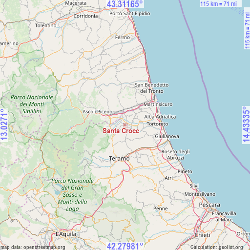
Santa Croce GPS coordinates[2]
42° 47' 52.368" North, 13° 43' 48.792" East
| Map corner | latitude | longitude |
|---|---|---|
| Upper-left | 43.31165°, | 13.0271° |
| Center: | 42.79788°, | 13.73022° |
| Lower-right: | 42.27981°, | 14.43335° |
| Map W x H: | 114.7×114.7 km | = 71.3×71.3mi |
| max Lat: | 47.04031° ⇑64.7% North |
| Santa Croce: | 42.79788° |
| min Lat: | ⇓35.3% South 35.50142° |
| min Long | Santa Croce | max Long |
| 6.69888° | 13.73022° | 18.48682° |
| W 75.9%⇐ | ⇒24.1% E |
Elevation
Elevation of Santa Croce is 262 m = 860 ft, and this is 44.7 m = 147 ft below average elevation for this country.
| Max E: |
2085 m = 6841 ft | 45.6% |
| Avg. | 306.7 m = 1006 ft | |
| Santa Croce | 262 m = 860 ft | |
Min E: |
-4 m = -13 ft | 54.4% |
See also: Italy elevation on elevation.city.
Geographical zone
Santa Croce is located in North temperate zone (between Tropic of Cancer and the Arctic Circle). Distance of this Northern Tropic circle is 2152.8 km =1337.7 mi to South.| Distance of | km | miles | from Santa Croce |
|---|---|---|---|
| North Pole | 5248.4 | 3261.2 | to North |
| Arctic Circle | 2642.5 | 1642 | to North |
| Tropic Cancer | 2152.8 | 1337.7 | to South |
| Equator | 4758.7 | 2956.9 | to South |


Nearby cities:
15 places around Santa Croce: (largest is in red/bold)
• Ancarano
4.6 km =2.9 mi,  16°
16°
• Campolungo-Villa Sant'Antonio
6.9 km =4.3 mi,  326°
326°
• Caselle
6.8 km =4.2 mi,  315°
315°
• Castel di Lama
7.4 km =4.6 mi,  353°
353°
• Civitella del Tronto
5.2 km =3.2 mi,  237°
237°
• Maltignano
5.1 km =3.2 mi, 317°
• Nereto
7.6 km =4.7 mi,  75°
75°
• Piane di Morro
6.9 km =4.3 mi,  294°
294°
• Piattoni-Villa Sant'Antonio
7.8 km =4.8 mi, 348°
• San Silvestro
7.7 km =4.8 mi,  359°
359°
• Sant'Egidio alla Vibrata
2.2 km =1.4 mi,  341°
341°
• Sant'Omero
4.9 km =3 mi,  100°
100°
• Sant'Onofrio-Floriano
4.1 km =2.5 mi,  171°
171°
• Torano Nuovo
4.8 km =3 mi,  53°
53°
• Villa Lempa
7 km =4.3 mi,  265°
265°
Sources, notices
• [Note1] Compared only with cities in Italy existing in our database
• [Src1] Map data: © OpenStreetMap contributors (CC-BY-SA)
• [Src2] Other city data from geonames.org with taken over terms of usage.
• [Src3] Geographical zone / Annual Mean Temperature by Robert A. Rohde @ Wikipedia
