Nereto geodata
Nereto (Abruzzo) is a seat of a third-order administrative division; located in Italy in Europe/Rome (GMT+2) time zone. With population of 3,951 people, there are 2420 cities with bigger population in this country. Compared to other cities in Italy, 64.6% of cities are located further ↑North; 76.8% of cities are located further ←West and 63.4% of cities have higher elevation than Nereto. Note1


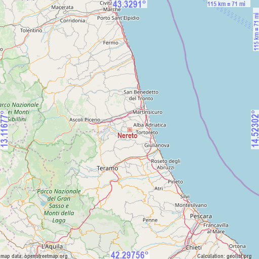
Nereto GPS coordinates[2]
42° 48' 55.728" North, 13° 49' 11.604" East
| Map corner | latitude | longitude |
|---|---|---|
| Upper-left | 43.3291°, | 13.11677° |
| Center: | 42.81548°, | 13.81989° |
| Lower-right: | 42.29756°, | 14.52302° |
| Map W x H: | 114.7×114.7 km | = 71.3×71.3mi |
| max Lat: | 47.04031° ⇑64.6% North |
| Nereto: | 42.81548° |
| min Lat: | ⇓35.4% South 35.50142° |
| min Long | Nereto | max Long |
| 6.69888° | 13.81989° | 18.48682° |
| W 76.8%⇐ | ⇒23.2% E |
Elevation
Elevation of Nereto is 138 m = 453 ft, and this is 168.7 m = 553 ft below average elevation for this country.
| Max E: |
2085 m = 6841 ft | 63.4% |
| Avg. | 306.7 m = 1006 ft | |
| Nereto | 138 m = 453 ft | |
Min E: |
-4 m = -13 ft | 36.6% |
See also: Italy elevation on elevation.city.
Geographical zone
Nereto is located in North temperate zone (between Tropic of Cancer and the Arctic Circle). Distance of this Northern Tropic circle is 2154.7 km =1338.9 mi to South.| Distance of | km | miles | from Nereto |
|---|---|---|---|
| North Pole | 5246.4 | 3260 | to North |
| Arctic Circle | 2640.5 | 1640.7 | to North |
| Tropic Cancer | 2154.7 | 1338.9 | to South |
| Equator | 4760.6 | 2958.1 | to South |


Nearby cities:
15 places around Nereto: (largest is in red/bold)
• Alba Adriatica
8.8 km =5.5 mi,  78°
78°
• Ancarano
6.5 km =4 mi,  292°
292°
• Bellante
8.1 km =5 mi,  190°
190°
• Colonnella
7.5 km =4.7 mi,  32°
32°
• Controguerra
4.3 km =2.7 mi,  357°
357°
• Corropoli
1.8 km =1.1 mi,  42°
42°
• Pagliare
7.3 km =4.5 mi,  325°
325°
• Salino
8.4 km =5.2 mi,  113°
113°
• Sant'Egidio alla Vibrata
8 km =5 mi,  271°
271°
• Sant'Omero
3.8 km =2.4 mi,  221°
221°
• Santa Croce
7.6 km =4.7 mi,  255°
255°
• Stella
8 km =5 mi,  353°
353°
• Torano Nuovo
3.6 km =2.2 mi,  283°
283°
• Tortoreto
7.7 km =4.8 mi,  99°
99°
• Villa San Giuseppe
8.5 km =5.3 mi,  313°
313°
Sources, notices
• [Note1] Compared only with cities in Italy existing in our database
• [Src1] Map data: © OpenStreetMap contributors (CC-BY-SA)
• [Src2] Other city data from geonames.org with taken over terms of usage.
• [Src3] Geographical zone / Annual Mean Temperature by Robert A. Rohde @ Wikipedia
