Noale geodata
Noale (Veneto) is a seat of a third-order administrative division; located in Italy in Europe/Rome (GMT+2) time zone. With population of 10,500 people, there are 900 cities with bigger population in this country. Compared to other cities in Italy, 75.1% of cities are located further ↓South; 56.8% of cities are located further ←West and 93.6% of cities have higher elevation than Noale. Note1


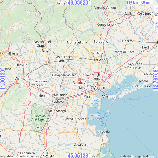
Noale GPS coordinates[2]
45° 32' 45.456" North, 12° 3' 52.02" East
| Map corner | latitude | longitude |
|---|---|---|
| Upper-left | 46.03623°, | 11.36133° |
| Center: | 45.54596°, | 12.06445° |
| Lower-right: | 45.05138°, | 12.76758° |
| Map W x H: | 109.5×109.5 km | = 68×68mi |
| max Lat: | 47.04031° ⇑24.9% North |
| Noale: | 45.54596° |
| min Lat: | ⇓75.1% South 35.50142° |
| min Long | Noale | max Long |
| 6.69888° | 12.06445° | 18.48682° |
| W 56.8%⇐ | ⇒43.2% E |
Elevation
Elevation of Noale is 11 m = 36 ft, and this is 295.7 m = 970 ft below average elevation for this country.
| Max E: |
2085 m = 6841 ft | 93.6% |
| Avg. | 306.7 m = 1006 ft | |
| Noale | 11 m = 36 ft | |
Min E: |
-4 m = -13 ft | 6.4% |
See also: Italy elevation on elevation.city.
Geographical zone
Noale is located in North temperate zone (between Tropic of Cancer and the Arctic Circle). Distance of this North polar circle is 2336.9 km =1452.1 mi to North.| Distance of | km | miles | from Noale |
|---|---|---|---|
| North Pole | 4942.8 | 3071.3 | to North |
| Arctic Circle | 2336.9 | 1452.1 | to North |
| Tropic Cancer | 2458.3 | 1527.5 | to South |
| Equator | 5064.2 | 3146.7 | to South |


Nearby cities:
15 places around Noale: (largest is in red/bold)
• Cappelletta
2.7 km =1.7 mi,  355°
355°
• Cavin-Botti
5.2 km =3.2 mi,  181°
181°
• Fossalta
5.8 km =3.6 mi,  304°
304°
• Massanzago-Ca' Baglioni-San Dono
4.6 km =2.9 mi,  284°
284°
• Moniego
2.4 km =1.5 mi,  45°
45°
• Rio San Martino
6.3 km =3.9 mi,  35°
35°
• Robegano
4.3 km =2.7 mi,  95°
95°
• Salzano
3.9 km =2.4 mi,  132°
132°
• Sant'Angelo
4.6 km =2.9 mi,  231°
231°
• Santa Maria di Sala
4.9 km =3 mi,  207°
207°
• Scorzè
4.8 km =3 mi, 49°
• Stigliano
3 km =1.9 mi, 212°
• Trebaseleghe
5.5 km =3.4 mi,  342°
342°
• Veternigo
3.2 km =2 mi,  189°
189°
• Zeminiana
3.4 km =2.1 mi,  245°
245°
Sources, notices
• [Note1] Compared only with cities in Italy existing in our database
• [Src1] Map data: © OpenStreetMap contributors (CC-BY-SA)
• [Src2] Other city data from geonames.org with taken over terms of usage.
• [Src3] Geographical zone / Annual Mean Temperature by Robert A. Rohde @ Wikipedia
