Farneto geodata
Farneto (Latium) is a populated place; located in Italy in Europe/Rome (GMT+2) time zone. With population of 620 people, there are 8840 cities with bigger population in this country. Compared to other cities in Italy, 75.1% of cities are located further ↑North; 66.6% of cities are located further ←West and 87% of cities have higher elevation than Farneto. Note1


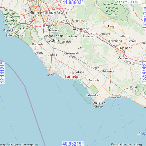
Farneto GPS coordinates[2]
41° 27' 40.5" North, 12° 50' 39.588" East
| Map corner | latitude | longitude |
|---|---|---|
| Upper-left | 41.98603°, | 12.14121° |
| Center: | 41.46125°, | 12.84433° |
| Lower-right: | 40.93219°, | 13.54746° |
| Map W x H: | 117.2×117.2 km | = 72.8×72.8mi |
| max Lat: | 47.04031° ⇑75.1% North |
| Farneto: | 41.46125° |
| min Lat: | ⇓24.9% South 35.50142° |
| min Long | Farneto | max Long |
| 6.69888° | 12.84433° | 18.48682° |
| W 66.6%⇐ | ⇒33.4% E |
Elevation
Elevation of Farneto is 25 m = 82 ft, and this is 281.7 m = 924 ft below average elevation for this country.
| Max E: |
2085 m = 6841 ft | 87% |
| Avg. | 306.7 m = 1006 ft | |
| Farneto | 25 m = 82 ft | |
Min E: |
-4 m = -13 ft | 13% |
See also: Italy elevation on elevation.city.
Geographical zone
Farneto is located in North temperate zone (between Tropic of Cancer and the Arctic Circle). Distance of this Northern Tropic circle is 2004.1 km =1245.3 mi to South.| Distance of | km | miles | from Farneto |
|---|---|---|---|
| North Pole | 5397 | 3353.5 | to North |
| Arctic Circle | 2791.1 | 1734.3 | to North |
| Tropic Cancer | 2004.1 | 1245.3 | to South |
| Equator | 4610.1 | 2864.6 | to South |


Nearby cities:
15 places around Farneto: (largest is in red/bold)
• Borgo Bainsizza
4.9 km =3 mi,  300°
300°
• Borgo Carso
8.9 km =5.5 mi,  24°
24°
• Borgo Flora
9.9 km =6.2 mi,  353°
353°
• Borgo Montello
8 km =5 mi,  313°
313°
• Borgo Piave
2.8 km =1.7 mi,  33°
33°
• Borgo Podgora
6 km =3.7 mi,  7°
7°
• Borgo Sabotino-Foce Verde
5 km =3.1 mi,  190°
190°
• Borgo San Michele
11.1 km =6.9 mi,  103°
103°
• Borgo Santa Maria
3.9 km =2.4 mi,  270°
270°
• Chiesuola
6.3 km =3.9 mi,  40°
40°
• Crocefisso
1.5 km =0.9 mi,  290°
290°
• Latina
5 km =3.1 mi,  83°
83°
• Latina Scalo
11.5 km =7.1 mi,  47°
47°
• Prato di Coppola
5.8 km =3.6 mi,  147°
147°
• Scopeto Madonna Gulia
10.7 km =6.6 mi,  113°
113°
Sources, notices
• [Note1] Compared only with cities in Italy existing in our database
• [Src1] Map data: © OpenStreetMap contributors (CC-BY-SA)
• [Src2] Other city data from geonames.org with taken over terms of usage.
• [Src3] Geographical zone / Annual Mean Temperature by Robert A. Rohde @ Wikipedia
