Alano geodata
Alano (Campania) is a populated place; located in Italy in Europe/Rome (GMT+2) time zone. With population of 594 people, there are 9062 cities with bigger population in this country. Compared to other cities in Italy, 85.5% of cities are located further ↑North; 86.9% of cities are located further ←West and 82.2% of cities have higher elevation than Alano. Note1


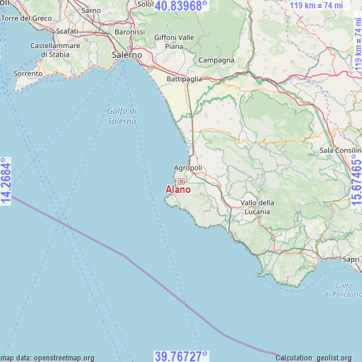
Alano GPS coordinates[2]
40° 18' 20.16" North, 14° 58' 17.472" East
| Map corner | latitude | longitude |
|---|---|---|
| Upper-left | 40.83968°, | 14.2684° |
| Center: | 40.3056°, | 14.97152° |
| Lower-right: | 39.76727°, | 15.67465° |
| Map W x H: | 119.2×119.2 km | = 74.1×74.1mi |
| max Lat: | 47.04031° ⇑85.5% North |
| Alano: | 40.3056° |
| min Lat: | ⇓14.5% South 35.50142° |
| min Long | Alano | max Long |
| 6.69888° | 14.97152° | 18.48682° |
| W 86.9%⇐ | ⇒13.1% E |
Elevation
Elevation of Alano is 41 m = 135 ft, and this is 265.7 m = 872 ft below average elevation for this country.
| Max E: |
2085 m = 6841 ft | 82.2% |
| Avg. | 306.7 m = 1006 ft | |
| Alano | 41 m = 135 ft | |
Min E: |
-4 m = -13 ft | 17.8% |
See also: Italy elevation on elevation.city.
Geographical zone
Alano is located in North temperate zone (between Tropic of Cancer and the Arctic Circle). Distance of this Northern Tropic circle is 1875.6 km =1165.4 mi to South.| Distance of | km | miles | from Alano |
|---|---|---|---|
| North Pole | 5525.5 | 3433.4 | to North |
| Arctic Circle | 2919.6 | 1814.2 | to North |
| Tropic Cancer | 1875.6 | 1165.4 | to South |
| Equator | 4481.6 | 2784.7 | to South |


Nearby cities:
15 places around Alano: (largest is in red/bold)
• Agropoli
5.1 km =3.2 mi,  18°
18°
• Castellabate
2.9 km =1.8 mi,  204°
204°
• Copersito
7.8 km =4.8 mi,  82°
82°
• Laureana Cilento
5.7 km =3.5 mi,  95°
95°
• Lustra
8.4 km =5.2 mi, 103°
• Mattine
10 km =6.2 mi,  26°
26°
• Montecorice
8 km =5 mi,  171°
171°
• Ogliastro Cilento
8.1 km =5 mi,  51°
51°
• Perdifumo
5.7 km =3.5 mi,  138°
138°
• Prignano Cilento
8.7 km =5.4 mi,  69°
69°
• Rutino
8.6 km =5.3 mi,  93°
93°
• San Marco
5.1 km =3.2 mi,  213°
213°
• Santa Maria
1.9 km =1.2 mi,  242°
242°
• Serramezzana
8.5 km =5.3 mi, 142°
• Torchiara
7.2 km =4.5 mi, 75°
Sources, notices
• [Note1] Compared only with cities in Italy existing in our database
• [Src1] Map data: © OpenStreetMap contributors (CC-BY-SA)
• [Src2] Other city data from geonames.org with taken over terms of usage.
• [Src3] Geographical zone / Annual Mean Temperature by Robert A. Rohde @ Wikipedia
