Agropoli geodata
Agropoli (Campania) is a seat of a third-order administrative division; located in Italy in Europe/Rome (GMT+2) time zone. With population of 17,335 people, there are 511 cities with bigger population in this country. Compared to other cities in Italy, 85.2% of cities are located further ↑North; 87.1% of cities are located further ←West and 88.7% of cities have higher elevation than Agropoli. Note1


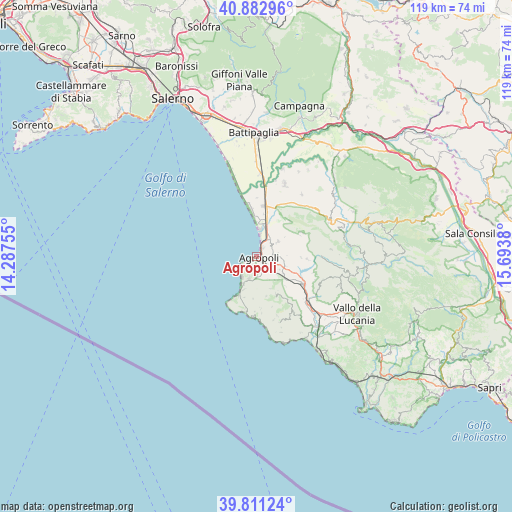
Agropoli GPS coordinates[2]
40° 20' 57.228" North, 14° 59' 26.412" East
| Map corner | latitude | longitude |
|---|---|---|
| Upper-left | 40.88296°, | 14.28755° |
| Center: | 40.34923°, | 14.99067° |
| Lower-right: | 39.81124°, | 15.6938° |
| Map W x H: | 119.2×119.2 km | = 74.1×74.1mi |
| max Lat: | 47.04031° ⇑85.2% North |
| Agropoli: | 40.34923° |
| min Lat: | ⇓14.8% South 35.50142° |
| min Long | Agropoli | max Long |
| 6.69888° | 14.99067° | 18.48682° |
| W 87.1%⇐ | ⇒12.9% E |
Elevation
Elevation of Agropoli is 21 m = 69 ft, and this is 285.7 m = 937 ft below average elevation for this country.
| Max E: |
2085 m = 6841 ft | 88.7% |
| Avg. | 306.7 m = 1006 ft | |
| Agropoli | 21 m = 69 ft | |
Min E: |
-4 m = -13 ft | 11.3% |
See also: Italy elevation on elevation.city.
Geographical zone
Agropoli is located in North temperate zone (between Tropic of Cancer and the Arctic Circle). Distance of this Northern Tropic circle is 1880.5 km =1168.5 mi to South.| Distance of | km | miles | from Agropoli |
|---|---|---|---|
| North Pole | 5520.6 | 3430.3 | to North |
| Arctic Circle | 2914.8 | 1811.2 | to North |
| Tropic Cancer | 1880.5 | 1168.5 | to South |
| Equator | 4486.4 | 2787.7 | to South |


Nearby cities:
15 places around Agropoli: (largest is in red/bold)
• Alano
5.1 km =3.2 mi,  198°
198°
• Castellabate
8 km =5 mi, 200°
• Copersito
7.2 km =4.5 mi,  122°
122°
• Laura
9.2 km =5.7 mi,  359°
359°
• Laureana Cilento
6.7 km =4.2 mi,  142°
142°
• Licinella-Torre di Paestum
6.4 km =4 mi,  5°
5°
• Lustra
9.4 km =5.8 mi, 135°
• Mattine
5 km =3.1 mi,  35°
35°
• Ogliastro Cilento
4.7 km =2.9 mi,  87°
87°
• Perdifumo
9.4 km =5.8 mi,  166°
166°
• Prignano Cilento
6.7 km =4.2 mi,  105°
105°
• Rutino
8.8 km =5.5 mi,  127°
127°
• Santa Maria
6.6 km =4.1 mi,  209°
209°
• Santa Venere
7.1 km =4.4 mi,  15°
15°
• Torchiara
6.2 km =3.9 mi, 119°
Sources, notices
• [Note1] Compared only with cities in Italy existing in our database
• [Src1] Map data: © OpenStreetMap contributors (CC-BY-SA)
• [Src2] Other city data from geonames.org with taken over terms of usage.
• [Src3] Geographical zone / Annual Mean Temperature by Robert A. Rohde @ Wikipedia
