Savazza geodata
Savazza (Emilia-Romagna) is a populated place; located in Italy in Europe/Rome (GMT+2) time zone. With population of 580 people, there are 9180 cities with bigger population in this country. Compared to other cities in Italy, 51.9% of cities are located further ↑North; 51.9% of cities are located further →East and 50% of cities have lower elevation than Savazza. Note1


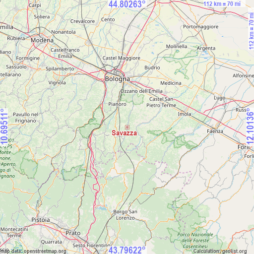
Savazza GPS coordinates[2]
44° 18' 5.688" North, 11° 23' 53.628" East
| Map corner | latitude | longitude |
|---|---|---|
| Upper-left | 44.80263°, | 10.69511° |
| Center: | 44.30158°, | 11.39823° |
| Lower-right: | 43.79622°, | 12.10136° |
| Map W x H: | 111.9×111.9 km | = 69.5×69.5mi |
| max Lat: | 47.04031° ⇑51.9% North |
| Savazza: | 44.30158° |
| min Lat: | ⇓48.1% South 35.50142° |
| min Long | Savazza | max Long |
| 6.69888° | 11.39823° | 18.48682° |
| W 48.1%⇐ | ⇒51.9% E |
Elevation
Elevation of Savazza is 235 m = 771 ft, and this is 71.7 m = 235 ft below average elevation for this country.
| Max E: |
2085 m = 6841 ft | 50% |
| Avg. | 306.7 m = 1006 ft | |
| Savazza | 235 m = 771 ft | |
Min E: |
-4 m = -13 ft | 50% |
See also: Italy elevation on elevation.city.
Geographical zone
Savazza is located in North temperate zone (between Tropic of Cancer and the Arctic Circle). Distance of this Northern Tropic circle is 2320 km =1441.6 mi to South.| Distance of | km | miles | from Savazza |
|---|---|---|---|
| North Pole | 5081.2 | 3157.3 | to North |
| Arctic Circle | 2475.3 | 1538.1 | to North |
| Tropic Cancer | 2320 | 1441.6 | to South |
| Equator | 4925.9 | 3060.8 | to South |


Nearby cities:
15 places around Savazza: (largest is in red/bold)
• Borgo Tossignano
15.9 km =9.9 mi,  97°
97°
• Castel del Rio
12.9 km =8 mi,  139°
139°
• Fontana
15.7 km =9.8 mi,  305°
305°
• Fontanelice
13.6 km =8.5 mi,  110°
110°
• Loiano
6.7 km =4.2 mi,  236°
236°
• Marzabotto
16 km =9.9 mi,  286°
286°
• Mercatale
10.3 km =6.4 mi,  14°
14°
• Monghidoro
10.6 km =6.6 mi,  214°
214°
• Monterenzio
2.8 km =1.7 mi, 10°
• Monzuno
10.8 km =6.7 mi,  256°
256°
• Pianoro
10.7 km =6.6 mi,  335°
335°
• Pizzano
6.1 km =3.8 mi, 12°
• Rastignano-Carteria di Sesto
15.3 km =9.5 mi,  347°
347°
• Sasso Marconi
16 km =9.9 mi, 313°
• Vado
11.2 km =7 mi,  278°
278°
Sources, notices
• [Note1] Compared only with cities in Italy existing in our database
• [Src1] Map data: © OpenStreetMap contributors (CC-BY-SA)
• [Src2] Other city data from geonames.org with taken over terms of usage.
• [Src3] Geographical zone / Annual Mean Temperature by Robert A. Rohde @ Wikipedia
