Murta Maria geodata
Murta Maria (Sardinia) is a populated place; located in Italy in Europe/Rome (GMT+2) time zone. With population of 539 people, there are 9552 cities with bigger population in this country. Compared to other cities in Italy, 80.1% of cities are located further ↑North; 72.2% of cities are located further →East and 94.1% of cities have higher elevation than Murta Maria. Note1


Murta Maria GPS coordinates[2]
40° 53' 25.224" North, 9° 35' 16.188" East
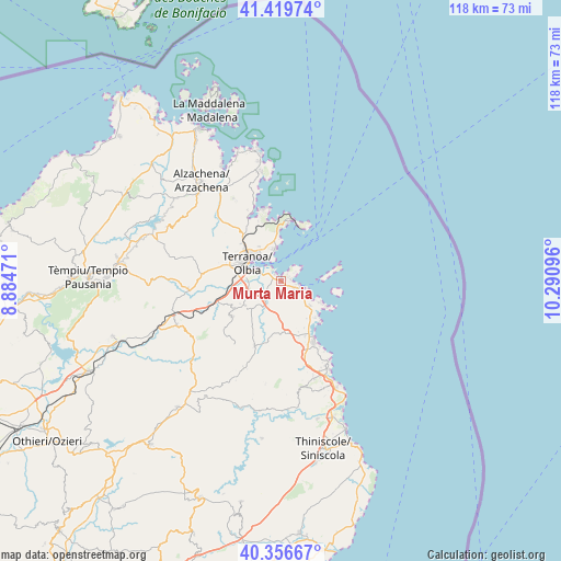
| Map corner | latitude | longitude |
|---|---|---|
| Upper-left | 41.41974°, | 8.88471° |
| Center: | 40.89034°, | 9.58783° |
| Lower-right: | 40.35667°, | 10.29096° |
| Map W x H: | 118.2×118.2 km | = 73.4×73.4mi |
| max Lat: | 47.04031° ⇑80.1% North |
| Murta Maria: | 40.89034° |
| min Lat: | ⇓19.9% South 35.50142° |
| min Long | Murta Maria | max Long |
| 6.69888° | 9.58783° | 18.48682° |
| W 27.8%⇐ | ⇒72.2% E |
Elevation
Elevation of Murta Maria is 10 m = 33 ft, and this is 296.7 m = 973 ft below average elevation for this country.
| Max E: |
2085 m = 6841 ft | 94.1% |
| Avg. | 306.7 m = 1006 ft | |
| Murta Maria | 10 m = 33 ft | |
Min E: |
-4 m = -13 ft | 5.9% |
See also: Italy elevation on elevation.city.
Geographical zone
Murta Maria is located in North temperate zone (between Tropic of Cancer and the Arctic Circle). Distance of this Northern Tropic circle is 1940.7 km =1205.9 mi to South.| Distance of | km | miles | from Murta Maria |
|---|---|---|---|
| North Pole | 5460.5 | 3393 | to North |
| Arctic Circle | 2854.6 | 1773.8 | to North |
| Tropic Cancer | 1940.7 | 1205.9 | to South |
| Equator | 4546.6 | 2825.1 | to South |


Nearby cities:
15 places around Murta Maria: (largest is in red/bold)
• Berchiddeddu
12.9 km =8 mi,  234°
234°
• Buddittogliu Straulas
17.1 km =10.6 mi,  163°
163°
• Budoni
22.8 km =14.2 mi,  154°
154°
• Golfo Aranci
11 km =6.8 mi,  20°
20°
• Golfo Aranci
13.1 km =8.1 mi,  9°
9°
• Loiri Porto San Paolo
9.2 km =5.7 mi, 234°
• Monti
23.9 km =14.9 mi,  247°
247°
• Olbia
8.4 km =5.2 mi,  295°
295°
• Padru
14.9 km =9.3 mi,  202°
202°
• Pittulongu
6.6 km =4.1 mi,  346°
346°
• Porto San Paolo
3.7 km =2.3 mi,  116°
116°
• San Pantaleo
20 km =12.4 mi,  329°
329°
• San Teodoro
14.7 km =9.1 mi, 152°
• Tanaunella
25.7 km =16 mi, 153°
• Telti
19.8 km =12.3 mi,  265°
265°
Sources, notices
• [Note1] Compared only with cities in Italy existing in our database
• [Src1] Map data: © OpenStreetMap contributors (CC-BY-SA)
• [Src2] Other city data from geonames.org with taken over terms of usage.
• [Src3] Geographical zone / Annual Mean Temperature by Robert A. Rohde @ Wikipedia
