Padru geodata
Padru (Sardinia) is a seat of a third-order administrative division; located in Italy in Europe/Rome (GMT+2) time zone. With population of 1,083 people, there are 6354 cities with bigger population in this country. Compared to other cities in Italy, 81.7% of cities are located further ↑North; 73% of cities are located further →East and 60% of cities have higher elevation than Padru. Note1


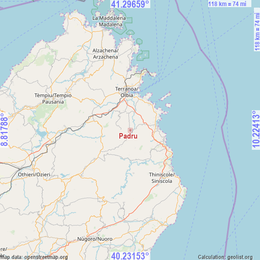
Padru GPS coordinates[2]
40° 45' 58.284" North, 9° 31' 15.6" East
| Map corner | latitude | longitude |
|---|---|---|
| Upper-left | 41.29659°, | 8.81788° |
| Center: | 40.76619°, | 9.521° |
| Lower-right: | 40.23153°, | 10.22413° |
| Map W x H: | 118.4×118.4 km | = 73.6×73.6mi |
| max Lat: | 47.04031° ⇑81.7% North |
| Padru: | 40.76619° |
| min Lat: | ⇓18.3% South 35.50142° |
| min Long | Padru | max Long |
| 6.69888° | 9.521° | 18.48682° |
| W 27%⇐ | ⇒73% E |
Elevation
Elevation of Padru is 163 m = 535 ft, and this is 143.7 m = 471 ft below average elevation for this country.
| Max E: |
2085 m = 6841 ft | 60% |
| Avg. | 306.7 m = 1006 ft | |
| Padru | 163 m = 535 ft | |
Min E: |
-4 m = -13 ft | 40% |
See also: Italy elevation on elevation.city.
Geographical zone
Padru is located in North temperate zone (between Tropic of Cancer and the Arctic Circle). Distance of this Northern Tropic circle is 1926.9 km =1197.3 mi to South.| Distance of | km | miles | from Padru |
|---|---|---|---|
| North Pole | 5474.3 | 3401.6 | to North |
| Arctic Circle | 2868.4 | 1782.3 | to North |
| Tropic Cancer | 1926.9 | 1197.3 | to South |
| Equator | 4532.8 | 2816.6 | to South |


Nearby cities:
15 places around Padru: (largest is in red/bold)
• Alà dei Sardi
20.8 km =12.9 mi,  231°
231°
• Berchiddeddu
7.9 km =4.9 mi,  322°
322°
• Buddittogliu Straulas
10.9 km =6.8 mi,  103°
103°
• Budoni
16.9 km =10.5 mi,  113°
113°
• Lodè
19.5 km =12.1 mi,  175°
175°
• Loiri Porto San Paolo
8.7 km =5.4 mi,  347°
347°
• Monti
17.1 km =10.6 mi,  285°
285°
• Murta Maria
14.9 km =9.3 mi,  22°
22°
• Olbia
17.6 km =10.9 mi, 353°
• Pittulongu
20.6 km =12.8 mi,  11°
11°
• Porto San Paolo
15.1 km =9.4 mi,  36°
36°
• San Teodoro
12.5 km =7.8 mi,  86°
86°
• Tanaunella
19.5 km =12.1 mi,  117°
117°
• Telti
18.6 km =11.6 mi,  310°
310°
• Torpè
20.4 km =12.7 mi,  139°
139°
Sources, notices
• [Note1] Compared only with cities in Italy existing in our database
• [Src1] Map data: © OpenStreetMap contributors (CC-BY-SA)
• [Src2] Other city data from geonames.org with taken over terms of usage.
• [Src3] Geographical zone / Annual Mean Temperature by Robert A. Rohde @ Wikipedia
