Monti geodata
Monti (Sardinia) is a seat of a third-order administrative division; located in Italy in Europe/Rome (GMT+2) time zone. With population of 1,759 people, there are 4555 cities with bigger population in this country. Compared to other cities in Italy, 81.3% of cities are located further ↑North; 75.9% of cities are located further →East and 58.6% of cities have lower elevation than Monti. Note1


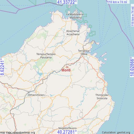
Monti GPS coordinates[2]
40° 48' 25.74" North, 9° 19' 31.908" East
| Map corner | latitude | longitude |
|---|---|---|
| Upper-left | 41.33722°, | 8.62241° |
| Center: | 40.80715°, | 9.32553° |
| Lower-right: | 40.27281°, | 10.02866° |
| Map W x H: | 118.4×118.3 km | = 73.6×73.5mi |
| max Lat: | 47.04031° ⇑81.3% North |
| Monti: | 40.80715° |
| min Lat: | ⇓18.7% South 35.50142° |
| min Long | Monti | max Long |
| 6.69888° | 9.32553° | 18.48682° |
| W 24.1%⇐ | ⇒75.9% E |
Elevation
Elevation of Monti is 289 m = 948 ft, and this is 17.7 m = 58 ft below average elevation for this country.
| Max E: |
2085 m = 6841 ft | 41.4% |
| Avg. | 306.7 m = 1006 ft | |
| Monti | 289 m = 948 ft | |
Min E: |
-4 m = -13 ft | 58.6% |
See also: Italy elevation on elevation.city.
Geographical zone
Monti is located in North temperate zone (between Tropic of Cancer and the Arctic Circle). Distance of this Northern Tropic circle is 1931.4 km =1200.1 mi to South.| Distance of | km | miles | from Monti |
|---|---|---|---|
| North Pole | 5469.7 | 3398.7 | to North |
| Arctic Circle | 2863.8 | 1779.5 | to North |
| Tropic Cancer | 1931.4 | 1200.1 | to South |
| Equator | 4537.3 | 2819.3 | to South |


Nearby cities:
15 places around Monti: (largest is in red/bold)
• Alà dei Sardi
17.5 km =10.9 mi,  179°
179°
• Berchidda
13.7 km =8.5 mi,  259°
259°
• Berchiddeddu
11.7 km =7.3 mi,  81°
81°
• Bortigiadas
25.5 km =15.8 mi,  291°
291°
• Calangianus
16.8 km =10.4 mi,  318°
318°
• Loiri Porto San Paolo
15.1 km =9.4 mi,  74°
74°
• Luras
19.2 km =11.9 mi, 318°
• Murta Maria
23.9 km =14.9 mi, 67°
• Olbia
19.4 km =12.1 mi,  48°
48°
• Oschiri
21.3 km =13.2 mi,  242°
242°
• Padru
17.1 km =10.6 mi,  105°
105°
• Pittulongu
25.8 km =16 mi, 52°
• Sant'Antonio di Gallura
20.6 km =12.8 mi,  354°
354°
• Telti
8 km =5 mi,  17°
17°
• Tempio Pausania
21.3 km =13.2 mi,  299°
299°
Sources, notices
• [Note1] Compared only with cities in Italy existing in our database
• [Src1] Map data: © OpenStreetMap contributors (CC-BY-SA)
• [Src2] Other city data from geonames.org with taken over terms of usage.
• [Src3] Geographical zone / Annual Mean Temperature by Robert A. Rohde @ Wikipedia
