Crociate geodata
Crociate (Sicily) is a populated place; located in Italy in Europe/Rome (GMT+2) time zone. With population of 505 people, there are 9881 cities with bigger population in this country. Compared to other cities in Italy, 97.9% of cities are located further ↑North; 81.8% of cities are located further ←West and 90.5% of cities have lower elevation than Crociate. Note1


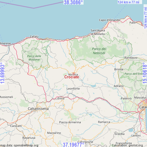
Crociate GPS coordinates[2]
37° 45' 17.172" North, 14° 24' 10.98" East
| Map corner | latitude | longitude |
|---|---|---|
| Upper-left | 38.3086°, | 13.69993° |
| Center: | 37.75477°, | 14.40305° |
| Lower-right: | 37.19677°, | 15.10618° |
| Map W x H: | 123.6×123.6 km | = 76.8×76.8mi |
| max Lat: | 47.04031° ⇑97.9% North |
| Crociate: | 37.75477° |
| min Lat: | ⇓2.1% South 35.50142° |
| min Long | Crociate | max Long |
| 6.69888° | 14.40305° | 18.48682° |
| W 81.8%⇐ | ⇒18.2% E |
Elevation
Elevation of Crociate is 732 m = 2402 ft, and this is 425.3 m = 1395 ft above average elevation for this country.
| Max E: |
2085 m = 6841 ft | 9.5% |
| Crociate | 732 m 2402 ft | |
| Avg. | 306.7 m = 1006 ft | |
Min E: |
-4 m = -13 ft | 90.5% |
See also: Italy elevation on elevation.city.
Geographical zone
Crociate is located in North temperate zone (between Tropic of Cancer and the Arctic Circle). Distance of this Northern Tropic circle is 1592 km =989.2 mi to South.| Distance of | km | miles | from Crociate |
|---|---|---|---|
| North Pole | 5809.1 | 3609.6 | to North |
| Arctic Circle | 3203.2 | 1990.4 | to North |
| Tropic Cancer | 1592 | 989.2 | to South |
| Equator | 4197.9 | 2608.5 | to South |


Nearby cities:
15 places around Crociate: (largest is in red/bold)
• Agira
15 km =9.3 mi,  136°
136°
• Assoro
14.8 km =9.2 mi,  174°
174°
• Capizzi
12.4 km =7.7 mi,  33°
33°
• Castel di Lucio
16.8 km =10.4 mi,  331°
331°
• Cerami
10.9 km =6.8 mi,  56°
56°
• Gagliano Castelferrato
12.7 km =7.9 mi,  113°
113°
• Gangi
18 km =11.2 mi,  284°
284°
• Leonforte
12.6 km =7.8 mi,  182°
182°
• Mistretta
19.7 km =12.2 mi,  348°
348°
• Nicosia
1.3 km =0.8 mi,  229°
229°
• Nissoria
11.9 km =7.4 mi,  160°
160°
• San Giorgio
14 km =8.7 mi, 155°
• Sperlinga
4.8 km =3 mi,  285°
285°
• Troina
17.3 km =10.7 mi,  79°
79°
• Villadoro
14.4 km =8.9 mi,  240°
240°
Sources, notices
• [Note1] Compared only with cities in Italy existing in our database
• [Src1] Map data: © OpenStreetMap contributors (CC-BY-SA)
• [Src2] Other city data from geonames.org with taken over terms of usage.
• [Src3] Geographical zone / Annual Mean Temperature by Robert A. Rohde @ Wikipedia
