Assoro geodata
Assoro (Sicily) is a seat of a third-order administrative division; located in Italy in Europe/Rome (GMT+2) time zone. With population of 3,958 people, there are 2418 cities with bigger population in this country. Compared to other cities in Italy, 98.4% of cities are located further ↑North; 82% of cities are located further ←West and 89.5% of cities have lower elevation than Assoro. Note1


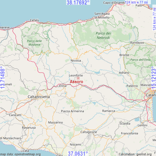
Assoro GPS coordinates[2]
37° 37' 19.56" North, 14° 25' 5.16" East
| Map corner | latitude | longitude |
|---|---|---|
| Upper-left | 38.17692°, | 13.71498° |
| Center: | 37.6221°, | 14.4181° |
| Lower-right: | 37.0631°, | 15.12123° |
| Map W x H: | 123.8×123.8 km | = 76.9×76.9mi |
| max Lat: | 47.04031° ⇑98.4% North |
| Assoro: | 37.6221° |
| min Lat: | ⇓1.6% South 35.50142° |
| min Long | Assoro | max Long |
| 6.69888° | 14.4181° | 18.48682° |
| W 82%⇐ | ⇒18% E |
Elevation
Elevation of Assoro is 706 m = 2316 ft, and this is 399.3 m = 1310 ft above average elevation for this country.
| Max E: |
2085 m = 6841 ft | 10.5% |
| Assoro | 706 m 2316 ft | |
| Avg. | 306.7 m = 1006 ft | |
Min E: |
-4 m = -13 ft | 89.5% |
See also: Italy elevation on elevation.city.
Geographical zone
Assoro is located in North temperate zone (between Tropic of Cancer and the Arctic Circle). Distance of this Northern Tropic circle is 1577.3 km =980.1 mi to South.| Distance of | km | miles | from Assoro |
|---|---|---|---|
| North Pole | 5823.9 | 3618.8 | to North |
| Arctic Circle | 3218 | 1999.6 | to North |
| Tropic Cancer | 1577.3 | 980.1 | to South |
| Equator | 4183.2 | 2599.3 | to South |


Nearby cities:
15 places around Assoro: (largest is in red/bold)
• Agira
9.7 km =6 mi,  67°
67°
• Calascibetta
13.4 km =8.3 mi,  254°
254°
• Crociate
14.8 km =9.2 mi,  354°
354°
• Enna
14.1 km =8.8 mi,  243°
243°
• Gagliano Castelferrato
14.2 km =8.8 mi,  46°
46°
• Leonforte
2.8 km =1.7 mi,  320°
320°
• Nicosia
14.1 km =8.8 mi, 350°
• Nissoria
4.4 km =2.7 mi,  36°
36°
• Pergusa
14.7 km =9.1 mi,  222°
222°
• Raddusa
19.3 km =12 mi,  147°
147°
• Regalbuto
19.7 km =12.2 mi,  80°
80°
• San Giorgio
4.9 km =3 mi, 65°
• Sperlinga
17.1 km =10.6 mi,  339°
339°
• Valguarnera Caropepe
14.3 km =8.9 mi,  189°
189°
• Villadoro
15.9 km =9.9 mi,  299°
299°
Sources, notices
• [Note1] Compared only with cities in Italy existing in our database
• [Src1] Map data: © OpenStreetMap contributors (CC-BY-SA)
• [Src2] Other city data from geonames.org with taken over terms of usage.
• [Src3] Geographical zone / Annual Mean Temperature by Robert A. Rohde @ Wikipedia
