Prato Lauro geodata
Prato Lauro (Latium) is a populated place; located in Italy in Europe/Rome (GMT+2) time zone. With population of 503 people, there are 9902 cities with bigger population in this country. Compared to other cities in Italy, 70.6% of cities are located further ↑North; 63.7% of cities are located further ←West and 76.1% of cities have higher elevation than Prato Lauro. Note1
Administrative division(s):
- Level 1: Latium
- Level 2: Città metropolitana di Roma Capitale
- Level 3: Roma Capitale
- Level 4: Municipio Roma IV


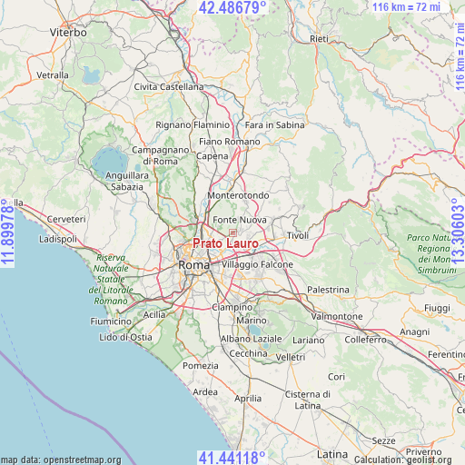
Prato Lauro GPS coordinates[2]
41° 57' 58.068" North, 12° 36' 10.44" East
| Map corner | latitude | longitude |
|---|---|---|
| Upper-left | 42.48679°, | 11.89978° |
| Center: | 41.96613°, | 12.6029° |
| Lower-right: | 41.44118°, | 13.30603° |
| Map W x H: | 116.3×116.3 km | = 72.3×72.3mi |
| max Lat: | 47.04031° ⇑70.6% North |
| Prato Lauro: | 41.96613° |
| min Lat: | ⇓29.4% South 35.50142° |
| min Long | Prato Lauro | max Long |
| 6.69888° | 12.6029° | 18.48682° |
| W 63.7%⇐ | ⇒36.3% E |
Elevation
Elevation of Prato Lauro is 69 m = 226 ft, and this is 237.7 m = 780 ft below average elevation for this country.
| Max E: |
2085 m = 6841 ft | 76.1% |
| Avg. | 306.7 m = 1006 ft | |
| Prato Lauro | 69 m = 226 ft | |
Min E: |
-4 m = -13 ft | 23.9% |
See also: Italy elevation on elevation.city.
Geographical zone
Prato Lauro is located in North temperate zone (between Tropic of Cancer and the Arctic Circle). Distance of this Northern Tropic circle is 2060.3 km =1280.2 mi to South.| Distance of | km | miles | from Prato Lauro |
|---|---|---|---|
| North Pole | 5340.9 | 3318.7 | to North |
| Arctic Circle | 2735 | 1699.4 | to North |
| Tropic Cancer | 2060.3 | 1280.2 | to South |
| Equator | 4666.2 | 2899.4 | to South |


Nearby cities:
15 places around Prato Lauro: (largest is in red/bold)
• Albuccione
8.1 km =5 mi,  100°
100°
• Andreuzza
8.4 km =5.2 mi,  53°
53°
• Colle Monfortani
8.8 km =5.5 mi,  154°
154°
• Colle Verde
1.8 km =1.1 mi, 47°
• Colleverde II
2.6 km =1.6 mi,  66°
66°
• Forno Casale
3.6 km =2.2 mi,  127°
127°
• Laghetto
4.4 km =2.7 mi,  88°
88°
• Marco Simone
3.9 km =2.4 mi,  107°
107°
• Mentana
8.4 km =5.2 mi,  23°
23°
• Monterotondo
9.6 km =6 mi,  8°
8°
• Pichini
7.7 km =4.8 mi,  59°
59°
• Pratolungo
1.4 km =0.9 mi,  142°
142°
• Santa Lucia
4.8 km =3 mi, 67°
• Setteville
4.7 km =2.9 mi,  121°
121°
• Tor Lupara
3.7 km =2.3 mi, 19°
Sources, notices
• [Note1] Compared only with cities in Italy existing in our database
• [Src1] Map data: © OpenStreetMap contributors (CC-BY-SA)
• [Src2] Other city data from geonames.org with taken over terms of usage.
• [Src3] Geographical zone / Annual Mean Temperature by Robert A. Rohde @ Wikipedia
