Covelo geodata
Covelo (Trentino-Alto Adige) is a seat of a third-order administrative division; located in Italy in Europe/Rome (GMT+2) time zone. With population of 440 people, there are 10128 cities with bigger population in this country. Compared to other cities in Italy, 91.4% of cities are located further ↓South; 56.3% of cities are located further →East and 80.7% of cities have lower elevation than Covelo. Note1
Administrative division(s):
- Level 1: Trentino-Alto Adige
- Level 2: Provincia autonoma di Trento
- Level 3: Cimone


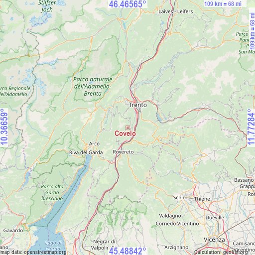
Covelo GPS coordinates[2]
45° 58' 45.084" North, 11° 4' 10.956" East
| Map corner | latitude | longitude |
|---|---|---|
| Upper-left | 46.46565°, | 10.36659° |
| Center: | 45.97919°, | 11.06971° |
| Lower-right: | 45.48842°, | 11.77284° |
| Map W x H: | 108.7×108.7 km | = 67.5×67.5mi |
| max Lat: | 47.04031° ⇑8.6% North |
| Covelo: | 45.97919° |
| min Lat: | ⇓91.4% South 35.50142° |
| min Long | Covelo | max Long |
| 6.69888° | 11.06971° | 18.48682° |
| W 43.7%⇐ | ⇒56.3% E |
Elevation
Elevation of Covelo is 535 m = 1755 ft, and this is 228.3 m = 749 ft above average elevation for this country.
| Max E: |
2085 m = 6841 ft | 19.3% |
| Covelo | 535 m 1755 ft | |
| Avg. | 306.7 m = 1006 ft | |
Min E: |
-4 m = -13 ft | 80.7% |
See also: Italy elevation on elevation.city.
Geographical zone
Covelo is located in North temperate zone (between Tropic of Cancer and the Arctic Circle). Distance of this North polar circle is 2288.8 km =1422.2 mi to North.| Distance of | km | miles | from Covelo |
|---|---|---|---|
| North Pole | 4894.7 | 3041.4 | to North |
| Arctic Circle | 2288.8 | 1422.2 | to North |
| Tropic Cancer | 2506.5 | 1557.5 | to South |
| Equator | 5112.4 | 3176.7 | to South |


Nearby cities:
15 places around Covelo: (largest is in red/bold)
• Aldeno
1.8 km =1.1 mi,  95°
95°
• Besenello
5 km =3.1 mi,  142°
142°
• Calliano
5.5 km =3.4 mi,  159°
159°
• Cavedine
7.6 km =4.7 mi,  283°
283°
• Cimoneri
0.6 km =0.4 mi,  14°
14°
• Garniga Nuova
3 km =1.9 mi,  27°
27°
• Mattarello
5.7 km =3.5 mi,  54°
54°
• Nomi
5.6 km =3.5 mi,  178°
178°
• Pedersano
7.6 km =4.7 mi,  210°
210°
• Pomarolo
6 km =3.7 mi,  199°
199°
• Ravina
7.5 km =4.7 mi, 26°
• Romagnano
5.1 km =3.2 mi, 32°
• Vigo
6.9 km =4.3 mi,  269°
269°
• Villa Lagarina
7.3 km =4.5 mi, 202°
• Volano
6.9 km =4.3 mi, 183°
Sources, notices
• [Note1] Compared only with cities in Italy existing in our database
• [Src1] Map data: © OpenStreetMap contributors (CC-BY-SA)
• [Src2] Other city data from geonames.org with taken over terms of usage.
• [Src3] Geographical zone / Annual Mean Temperature by Robert A. Rohde @ Wikipedia
