Mattarello geodata
Mattarello (Trentino-Alto Adige) is a populated place; located in Italy in Europe/Rome (GMT+2) time zone. With population of 5,214 people, there are 1873 cities with bigger population in this country. Compared to other cities in Italy, 92.2% of cities are located further ↓South; 55.5% of cities are located further →East and 55.5% of cities have higher elevation than Mattarello. Note1
Administrative division(s):
- Level 1: Trentino-Alto Adige
- Level 2: Provincia autonoma di Trento
- Level 3: Trento


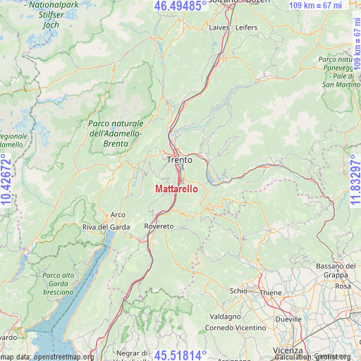
Mattarello GPS coordinates[2]
46° 0' 31.14" North, 11° 7' 47.424" East
| Map corner | latitude | longitude |
|---|---|---|
| Upper-left | 46.49485°, | 10.42672° |
| Center: | 46.00865°, | 11.12984° |
| Lower-right: | 45.51814°, | 11.83297° |
| Map W x H: | 108.6×108.6 km | = 67.5×67.5mi |
| max Lat: | 47.04031° ⇑7.8% North |
| Mattarello: | 46.00865° |
| min Lat: | ⇓92.2% South 35.50142° |
| min Long | Mattarello | max Long |
| 6.69888° | 11.12984° | 18.48682° |
| W 44.5%⇐ | ⇒55.5% E |
Elevation
Elevation of Mattarello is 199 m = 653 ft, and this is 107.7 m = 353 ft below average elevation for this country.
| Max E: |
2085 m = 6841 ft | 55.5% |
| Avg. | 306.7 m = 1006 ft | |
| Mattarello | 199 m = 653 ft | |
Min E: |
-4 m = -13 ft | 44.5% |
See also: Italy elevation on elevation.city.
Geographical zone
Mattarello is located in North temperate zone (between Tropic of Cancer and the Arctic Circle). Distance of this North polar circle is 2285.5 km =1420.1 mi to North.| Distance of | km | miles | from Mattarello |
|---|---|---|---|
| North Pole | 4891.4 | 3039.4 | to North |
| Arctic Circle | 2285.5 | 1420.1 | to North |
| Tropic Cancer | 2509.8 | 1559.5 | to South |
| Equator | 5115.7 | 3178.7 | to South |


Nearby cities:
15 places around Mattarello: (largest is in red/bold)
• Aldeno
4.5 km =2.8 mi,  219°
219°
• Besenello
7.4 km =4.6 mi,  192°
192°
• Bosentino-Migazzone
7.2 km =4.5 mi,  96°
96°
• Cimoneri
5.3 km =3.3 mi,  238°
238°
• Covelo
5.7 km =3.5 mi,  234°
234°
• Garniga Nuova
3.3 km =2.1 mi,  259°
259°
• Povo
6.8 km =4.2 mi,  16°
16°
• Ravina
3.7 km =2.3 mi,  338°
338°
• Romagnano
2.1 km =1.3 mi,  299°
299°
• Sardagna
6.7 km =4.2 mi, 337°
• Susà
8.5 km =5.3 mi,  56°
56°
• Tavernaro
8.5 km =5.3 mi,  13°
13°
• Trento
6.6 km =4.1 mi,  354°
354°
• Vattaro
7 km =4.3 mi, 103°
• Vigolo Vattaro
5.3 km =3.3 mi,  94°
94°
Sources, notices
• [Note1] Compared only with cities in Italy existing in our database
• [Src1] Map data: © OpenStreetMap contributors (CC-BY-SA)
• [Src2] Other city data from geonames.org with taken over terms of usage.
• [Src3] Geographical zone / Annual Mean Temperature by Robert A. Rohde @ Wikipedia
