Meano geodata
Meano (Trentino-Alto Adige) is a populated place; located in Italy in Europe/Rome (GMT+2) time zone. With population of 2,096 people, there are 3995 cities with bigger population in this country. Compared to other cities in Italy, 94.4% of cities are located further ↓South; 55.7% of cities are located further →East and 65.5% of cities have lower elevation than Meano. Note1
Administrative division(s):
- Level 1: Trentino-Alto Adige
- Level 2: Provincia autonoma di Trento
- Level 3: Trento


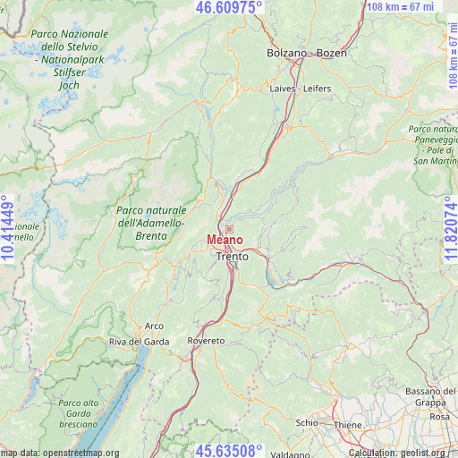
Meano GPS coordinates[2]
46° 7' 28.452" North, 11° 7' 3.396" East
| Map corner | latitude | longitude |
|---|---|---|
| Upper-left | 46.60975°, | 10.41449° |
| Center: | 46.12457°, | 11.11761° |
| Lower-right: | 45.63508°, | 11.82074° |
| Map W x H: | 108.4×108.4 km | = 67.4×67.4mi |
| max Lat: | 47.04031° ⇑5.6% North |
| Meano: | 46.12457° |
| min Lat: | ⇓94.4% South 35.50142° |
| min Long | Meano | max Long |
| 6.69888° | 11.11761° | 18.48682° |
| W 44.3%⇐ | ⇒55.7% E |
Elevation
Elevation of Meano is 348 m = 1142 ft, and this is 41.3 m = 135 ft above average elevation for this country.
| Max E: |
2085 m = 6841 ft | 34.5% |
| Meano | 348 m 1142 ft | |
| Avg. | 306.7 m = 1006 ft | |
Min E: |
-4 m = -13 ft | 65.5% |
See also: Italy elevation on elevation.city.
Geographical zone
Meano is located in North temperate zone (between Tropic of Cancer and the Arctic Circle). Distance of this North polar circle is 2272.6 km =1412.1 mi to North.| Distance of | km | miles | from Meano |
|---|---|---|---|
| North Pole | 4878.5 | 3031.4 | to North |
| Arctic Circle | 2272.6 | 1412.1 | to North |
| Tropic Cancer | 2522.7 | 1567.5 | to South |
| Equator | 5128.6 | 3186.8 | to South |


Nearby cities:
15 places around Meano: (largest is in red/bold)
• Albiano
6.3 km =3.9 mi,  69°
69°
• Cadine
5.4 km =3.4 mi,  224°
224°
• Gazzadina
1 km =0.6 mi,  58°
58°
• Giovo
4.4 km =2.7 mi,  37°
37°
• Lavis
2 km =1.2 mi,  341°
341°
• Nave San Rocco
4.9 km =3 mi,  348°
348°
• Palù
4.2 km =2.6 mi,  26°
26°
• Pressano
3.2 km =2 mi, 343°
• Tavernaro
5.5 km =3.4 mi,  147°
147°
• Trento
6.3 km =3.9 mi,  177°
177°
• Vela
4.8 km =3 mi,  194°
194°
• Verla
4.6 km =2.9 mi, 36°
• Vigo Meano
1.6 km =1 mi,  51°
51°
• Villamontagna
5.3 km =3.3 mi,  142°
142°
• Zambana
3.4 km =2.1 mi,  331°
331°
Sources, notices
• [Note1] Compared only with cities in Italy existing in our database
• [Src1] Map data: © OpenStreetMap contributors (CC-BY-SA)
• [Src2] Other city data from geonames.org with taken over terms of usage.
• [Src3] Geographical zone / Annual Mean Temperature by Robert A. Rohde @ Wikipedia
