Tavernaro geodata
Tavernaro (Trentino-Alto Adige) is a populated place; located in Italy in Europe/Rome (GMT+2) time zone. With population of 744 people, there are 7987 cities with bigger population in this country. Compared to other cities in Italy, 93.8% of cities are located further ↓South; 55% of cities are located further →East and 78.5% of cities have lower elevation than Tavernaro. Note1
Administrative division(s):
- Level 1: Trentino-Alto Adige
- Level 2: Provincia autonoma di Trento
- Level 3: Trento


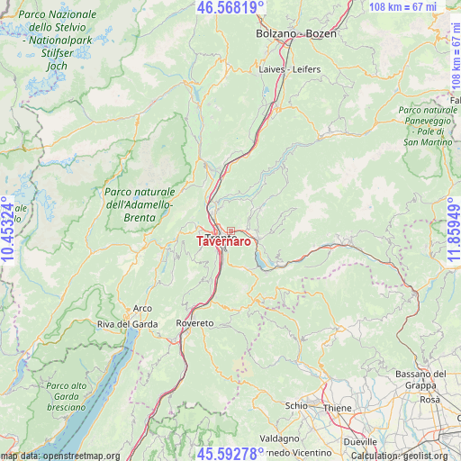
Tavernaro GPS coordinates[2]
46° 4' 57.504" North, 11° 9' 22.896" East
| Map corner | latitude | longitude |
|---|---|---|
| Upper-left | 46.56819°, | 10.45324° |
| Center: | 46.08264°, | 11.15636° |
| Lower-right: | 45.59278°, | 11.85949° |
| Map W x H: | 108.5×108.5 km | = 67.4×67.4mi |
| max Lat: | 47.04031° ⇑6.2% North |
| Tavernaro: | 46.08264° |
| min Lat: | ⇓93.8% South 35.50142° |
| min Long | Tavernaro | max Long |
| 6.69888° | 11.15636° | 18.48682° |
| W 45%⇐ | ⇒55% E |
Elevation
Elevation of Tavernaro is 500 m = 1640 ft, and this is 193.3 m = 634 ft above average elevation for this country.
| Max E: |
2085 m = 6841 ft | 21.5% |
| Tavernaro | 500 m 1640 ft | |
| Avg. | 306.7 m = 1006 ft | |
Min E: |
-4 m = -13 ft | 78.5% |
See also: Italy elevation on elevation.city.
Geographical zone
Tavernaro is located in North temperate zone (between Tropic of Cancer and the Arctic Circle). Distance of this North polar circle is 2277.3 km =1415 mi to North.| Distance of | km | miles | from Tavernaro |
|---|---|---|---|
| North Pole | 4883.2 | 3034.3 | to North |
| Arctic Circle | 2277.3 | 1415 | to North |
| Tropic Cancer | 2518 | 1564.6 | to South |
| Equator | 5123.9 | 3183.8 | to South |


Nearby cities:
15 places around Tavernaro: (largest is in red/bold)
• Civezzano
2.4 km =1.5 mi,  66°
66°
• Fornace
5.6 km =3.5 mi,  45°
45°
• Gazzadina
5.6 km =3.5 mi,  337°
337°
• Madrano-Canzolino
4.7 km =2.9 mi,  87°
87°
• Meano
5.5 km =3.4 mi,  327°
327°
• Pergine Valsugana
6.6 km =4.1 mi,  107°
107°
• Povo
1.7 km =1.1 mi,  183°
183°
• Ravina
5.9 km =3.7 mi,  215°
215°
• Sardagna
5.1 km =3.2 mi,  245°
245°
• Seregnano
3.3 km =2.1 mi, 74°
• Susà
6.1 km =3.8 mi,  125°
125°
• Trento
3.2 km =2 mi,  238°
238°
• Vela
4.2 km =2.6 mi,  269°
269°
• Vigo Meano
5.9 km =3.7 mi, 342°
• Villamontagna
0.5 km =0.3 mi,  25°
25°
Sources, notices
• [Note1] Compared only with cities in Italy existing in our database
• [Src1] Map data: © OpenStreetMap contributors (CC-BY-SA)
• [Src2] Other city data from geonames.org with taken over terms of usage.
• [Src3] Geographical zone / Annual Mean Temperature by Robert A. Rohde @ Wikipedia
