Vela geodata
Vela (Trentino-Alto Adige) is a populated place; located in Italy in Europe/Rome (GMT+2) time zone. With population of 963 people, there are 6808 cities with bigger population in this country. Compared to other cities in Italy, 93.7% of cities are located further ↓South; 55.9% of cities are located further →East and 56.2% of cities have higher elevation than Vela. Note1
Administrative division(s):
- Level 1: Trentino-Alto Adige
- Level 2: Provincia autonoma di Trento
- Level 3: Trento


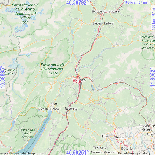
Vela GPS coordinates[2]
46° 4' 56.532" North, 11° 6' 7.452" East
| Map corner | latitude | longitude |
|---|---|---|
| Upper-left | 46.56792°, | 10.39895° |
| Center: | 46.08237°, | 11.10207° |
| Lower-right: | 45.59251°, | 11.8052° |
| Map W x H: | 108.5×108.5 km | = 67.4×67.4mi |
| max Lat: | 47.04031° ⇑6.3% North |
| Vela: | 46.08237° |
| min Lat: | ⇓93.7% South 35.50142° |
| min Long | Vela | max Long |
| 6.69888° | 11.10207° | 18.48682° |
| W 44.1%⇐ | ⇒55.9% E |
Elevation
Elevation of Vela is 194 m = 636 ft, and this is 112.7 m = 370 ft below average elevation for this country.
| Max E: |
2085 m = 6841 ft | 56.2% |
| Avg. | 306.7 m = 1006 ft | |
| Vela | 194 m = 636 ft | |
Min E: |
-4 m = -13 ft | 43.8% |
See also: Italy elevation on elevation.city.
Geographical zone
Vela is located in North temperate zone (between Tropic of Cancer and the Arctic Circle). Distance of this North polar circle is 2277.3 km =1415 mi to North.| Distance of | km | miles | from Vela |
|---|---|---|---|
| North Pole | 4883.2 | 3034.3 | to North |
| Arctic Circle | 2277.3 | 1415 | to North |
| Tropic Cancer | 2518 | 1564.6 | to South |
| Equator | 5123.9 | 3183.8 | to South |


Nearby cities:
15 places around Vela: (largest is in red/bold)
• Cadine
2.7 km =1.7 mi,  287°
287°
• Civezzano
6.4 km =4 mi,  81°
81°
• Gazzadina
5.6 km =3.5 mi,  21°
21°
• Lavis
6.6 km =4.1 mi,  4°
4°
• Meano
4.8 km =3 mi,  14°
14°
• Povo
4.4 km =2.7 mi,  112°
112°
• Ravina
4.8 km =3 mi,  170°
170°
• Romagnano
7.2 km =4.5 mi,  177°
177°
• Sardagna
2.1 km =1.3 mi,  192°
192°
• Seregnano
7.4 km =4.6 mi, 82°
• Tavernaro
4.2 km =2.6 mi,  89°
89°
• Terlago
4.7 km =2.9 mi, 290°
• Trento
2.2 km =1.4 mi,  137°
137°
• Vigo Meano
6.2 km =3.9 mi, 23°
• Villamontagna
4.4 km =2.7 mi, 83°
Sources, notices
• [Note1] Compared only with cities in Italy existing in our database
• [Src1] Map data: © OpenStreetMap contributors (CC-BY-SA)
• [Src2] Other city data from geonames.org with taken over terms of usage.
• [Src3] Geographical zone / Annual Mean Temperature by Robert A. Rohde @ Wikipedia
