Saint Ann’s Bay geodata
Saint Ann’s Bay (St Ann) is a seat of a first-order administrative division; located in Jamaica in America/Jamaica (GMT-5) time zone. With population of 13,671 people, there are 12 cities with bigger population in this country. Compared to other cities in Jamaica, 92.3% of cities are located further ↓South; 54.9% of cities are located further ←West and 83.5% of cities have higher elevation than Saint Ann’s Bay. Note1


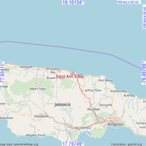
Saint Ann’s Bay GPS coordinates[2]
18° 26' 8.916" North, 77° 12' 3.528" West
| Map corner | latitude | longitude |
|---|---|---|
| Upper-left | 19.10154°, | -77.90411° |
| Center: | 18.43581°, | -77.20098° |
| Lower-right: | 17.76749°, | -76.49786° |
| Map W x H: | 148.3×148.3 km | = 92.1×92.1mi |
| max Lat: | 18.49358° ⇑7.7% North |
| Saint Ann’s Bay: | 18.43581° |
| min Lat: | ⇓92.3% South 17.774° |
| min Long | Saint Ann’s B | max Long |
| -78.3481° | -77.20098° | -76.24864° |
| W 54.9%⇐ | ⇒45.1% E |
Elevation
Elevation of Saint Ann’s Bay is 14 m = 46 ft, and this is 200.4 m = 657 ft below average elevation for this country.
| Max E: |
944 m = 3097 ft | 83.5% |
| Avg. | 214.4 m = 703 ft | |
| Saint Ann’s Bay | 14 m = 46 ft | |
Min E: |
1 m = 3 ft | 16.5% |
See also: Jamaica elevation on elevation.city.
Geographical zone
Saint Ann’s Bay is located in North Torrid zone (between Equator and Tropic of Cancer). Distance of this Northern Tropic circle is 556 km =345.5 mi to North.| Distance of | km | miles | from Saint Ann’s Bay |
|---|---|---|---|
| North Pole | 7957.2 | 4944.4 | to North |
| Arctic Circle | 5351.3 | 3325.1 | to North |
| Tropic Cancer | 556 | 345.5 | to North |
| Equator | 2049.9 | 1273.7 | to South |


Nearby cities:
15 places around Saint Ann’s Bay: (largest is in red/bold)
• Alexandria
21.5 km =13.4 mi,  228°
228°
• Bamboo
8.3 km =5.2 mi, 233°
• Discovery Bay
21.1 km =13.1 mi,  276°
276°
• Duncans
35.6 km =22.1 mi, 275°
• Ewarton
30.6 km =19 mi,  156°
156°
• Gayle
23.6 km =14.7 mi,  121°
121°
• Kellits
31.3 km =19.4 mi,  193°
193°
• Lluidas Vale
34.9 km =21.7 mi,  170°
170°
• Lucky Hill
24.5 km =15.2 mi, 124°
• Moneague
20.2 km =12.6 mi,  152°
152°
• Ocho Rios
10.8 km =6.7 mi,  106°
106°
• Oracabessa
27.1 km =16.8 mi,  97°
97°
• Port Maria
33.7 km =20.9 mi, 102°
• Runaway Bay
14.5 km =9 mi, 280°
• Ulster Spring
36.3 km =22.6 mi,  248°
248°
Sources, notices
• [Note1] Compared only with cities in Jamaica existing in our database
• [Src1] Map data: © OpenStreetMap contributors (CC-BY-SA)
• [Src2] Other city data from geonames.org with taken over terms of usage.
• [Src3] Geographical zone / Annual Mean Temperature by Robert A. Rohde @ Wikipedia
