Ewarton geodata
Ewarton (Saint Catherine) is a populated place; located in Jamaica in America/Jamaica (GMT-5) time zone. With population of 12,797 people, there are 15 cities with bigger population in this country. Compared to other cities in Jamaica, 58.2% of cities are located further ↓South; 62.6% of cities are located further ←West and 65.9% of cities have lower elevation than Ewarton. Note1


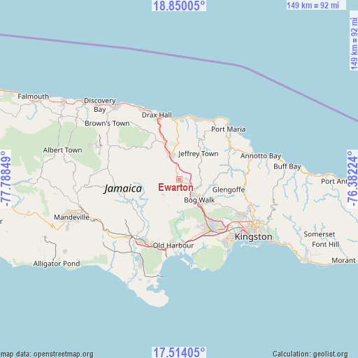
Ewarton GPS coordinates[2]
18° 10' 59.988" North, 77° 5' 7.296" West
| Map corner | latitude | longitude |
|---|---|---|
| Upper-left | 18.85005°, | -77.78849° |
| Center: | 18.18333°, | -77.08536° |
| Lower-right: | 17.51405°, | -76.38224° |
| Map W x H: | 148.5×148.6 km | = 92.3×92.3mi |
| max Lat: | 18.49358° ⇑41.8% North |
| Ewarton: | 18.18333° |
| min Lat: | ⇓58.2% South 17.774° |
| min Long | Ewarton | max Long |
| -78.3481° | -77.08536° | -76.24864° |
| W 62.6%⇐ | ⇒37.4% E |
Elevation
Elevation of Ewarton is 226 m = 741 ft, and this is 11.6 m = 38 ft above average elevation for this country.
| Max E: |
944 m = 3097 ft | 34.1% |
| Ewarton | 226 m 741 ft | |
| Avg. | 214.4 m = 703 ft | |
Min E: |
1 m = 3 ft | 65.9% |
See also: Jamaica elevation on elevation.city.
Geographical zone
Ewarton is located in North Torrid zone (between Equator and Tropic of Cancer). Distance of this Northern Tropic circle is 584.1 km =362.9 mi to North.| Distance of | km | miles | from Ewarton |
|---|---|---|---|
| North Pole | 7985.3 | 4961.8 | to North |
| Arctic Circle | 5379.4 | 3342.6 | to North |
| Tropic Cancer | 584.1 | 362.9 | to North |
| Equator | 2021.8 | 1256.3 | to South |


Nearby cities:
15 places around Ewarton: (largest is in red/bold)
• Bog Walk
12.4 km =7.7 mi,  136°
136°
• Chapelton
22.2 km =13.8 mi,  239°
239°
• Gayle
17.8 km =11.1 mi,  26°
26°
• Islington
28.1 km =17.5 mi,  60°
60°
• Kellits
19.7 km =12.2 mi,  263°
263°
• Linstead
7.7 km =4.8 mi,  132°
132°
• Lluidas Vale
9.2 km =5.7 mi,  226°
226°
• Lucky Hill
16.2 km =10.1 mi, 29°
• Moneague
10.6 km =6.6 mi,  344°
344°
• Ocho Rios
25 km =15.5 mi,  355°
355°
• Old Harbour
27 km =16.8 mi,  185°
185°
• Point Hill
10.7 km =6.6 mi, 192°
• Richmond
22.3 km =13.9 mi,  69°
69°
• Riversdale
12.9 km =8 mi,  98°
98°
• Spanish Town
25.3 km =15.7 mi,  147°
147°
Sources, notices
• [Note1] Compared only with cities in Jamaica existing in our database
• [Src1] Map data: © OpenStreetMap contributors (CC-BY-SA)
• [Src2] Other city data from geonames.org with taken over terms of usage.
• [Src3] Geographical zone / Annual Mean Temperature by Robert A. Rohde @ Wikipedia
