Duncans geodata
Duncans (Trelawny) is a populated place; located in Jamaica in America/Jamaica (GMT-5) time zone. With population of 1,876 people, there are 76 cities with bigger population in this country. Compared to other cities in Jamaica, 97.8% of cities are located further ↓South; 65.9% of cities are located further →East and 53.8% of cities have lower elevation than Duncans. Note1


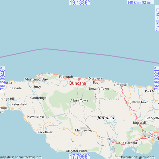
Duncans GPS coordinates[2]
18° 28' 4.8" North, 77° 32' 10.788" West
| Map corner | latitude | longitude |
|---|---|---|
| Upper-left | 19.1336°, | -78.23946° |
| Center: | 18.468°, | -77.53633° |
| Lower-right: | 17.7998°, | -76.83321° |
| Map W x H: | 148.3×148.3 km | = 92.1×92.1mi |
| max Lat: | 18.49358° ⇑2.2% North |
| Duncans: | 18.468° |
| min Lat: | ⇓97.8% South 17.774° |
| min Long | Duncans | max Long |
| -78.3481° | -77.53633° | -76.24864° |
| W 34.1%⇐ | ⇒65.9% E |
Elevation
Elevation of Duncans is 130 m = 427 ft, and this is 84.4 m = 277 ft below average elevation for this country.
| Max E: |
944 m = 3097 ft | 46.2% |
| Avg. | 214.4 m = 703 ft | |
| Duncans | 130 m = 427 ft | |
Min E: |
1 m = 3 ft | 53.8% |
See also: Jamaica elevation on elevation.city.
Geographical zone
Duncans is located in North Torrid zone (between Equator and Tropic of Cancer). Distance of this Northern Tropic circle is 552.5 km =343.3 mi to North.| Distance of | km | miles | from Duncans |
|---|---|---|---|
| North Pole | 7953.6 | 4942.1 | to North |
| Arctic Circle | 5347.7 | 3322.9 | to North |
| Tropic Cancer | 552.5 | 343.3 | to North |
| Equator | 2053.4 | 1275.9 | to South |


Nearby cities:
15 places around Duncans: (largest is in red/bold)
• Albert Town
19.3 km =12 mi,  181°
181°
• Alexandria
26.3 km =16.3 mi,  132°
132°
• Balaclava
34.8 km =21.6 mi,  199°
199°
• Bamboo
29.9 km =18.6 mi,  106°
106°
• Coleyville
29.1 km =18.1 mi,  174°
174°
• Discovery Bay
14.4 km =8.9 mi,  94°
94°
• Falmouth
12.9 km =8 mi,  282°
282°
• Limit
35.7 km =22.2 mi, 168°
• Maroon Town
30.6 km =19 mi,  243°
243°
• Quickstep
25.6 km =15.9 mi,  206°
206°
• Rock Spring
18.6 km =11.6 mi,  185°
185°
• Runaway Bay
21.2 km =13.2 mi, 92°
• Saint Ann’s Bay
35.6 km =22.1 mi,  95°
95°
• Ulster Spring
17.1 km =10.6 mi, 174°
• Wakefield
20.5 km =12.7 mi,  252°
252°
Sources, notices
• [Note1] Compared only with cities in Jamaica existing in our database
• [Src1] Map data: © OpenStreetMap contributors (CC-BY-SA)
• [Src2] Other city data from geonames.org with taken over terms of usage.
• [Src3] Geographical zone / Annual Mean Temperature by Robert A. Rohde @ Wikipedia
