Tosu geodata
Tosu (Saga) is a seat of a second-order administrative division; located in Japan in Asia/Tokyo (GMT+9) time zone. With population of 63,595 people, there are 307 cities with bigger population in this country. Compared to other cities in Japan, 87.1% of cities are located further ↑North; 92.2% of cities are located further →East and 62.8% of cities have higher elevation than Tosu. Note1


Tosu GPS coordinates[2]
33° 22' 0.012" North, 130° 31' 0.012" East
| Map corner | latitude | longitude |
|---|---|---|
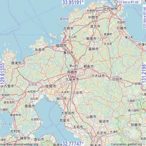
| Upper-left | 33.95191°, | 129.81355° |
| Center: | 33.36667°, | 130.51667° |
| Lower-right: | 32.77747°, | 131.2198° |
| Map W x H: | 130.6×130.6 km | = 81.2×81.2mi |
| max Lat: | 45.40944° ⇑87.1% North |
| Tosu: | 33.36667° |
| min Lat: | ⇓12.9% South 24.34478° |
| min Long | Tosu | max Long |
| 123° | 130.51667° | 145.575° |
| W 7.8%⇐ | ⇒92.2% E |
Elevation
Elevation of Tosu is 17 m = 56 ft, and this is 67.6 m = 222 ft below average elevation for this country.
| Max E: |
1086 m = 3563 ft | 62.8% |
| Avg. | 84.6 m = 278 ft | |
| Tosu | 17 m = 56 ft | |
Min E: |
-2 m = -7 ft | 37.2% |
See also: Tosu elevation on elevation.city.
Geographical zone
Tosu is located in North temperate zone (between Tropic of Cancer and the Arctic Circle). Distance of this Northern Tropic circle is 1104.1 km =686.1 mi to South.| Distance of | km | miles | from Tosu |
|---|---|---|---|
| North Pole | 6297 | 3912.8 | to North |
| Arctic Circle | 3691.1 | 2293.5 | to North |
| Tropic Cancer | 1104.1 | 686.1 | to South |
| Equator | 3710 | 2305.3 | to South |


Nearby cities:
15 places around Tosu: (largest is in red/bold)
• Amagi
14 km =8.7 mi,  65°
65°
• Asakura
19.5 km =12.1 mi, 74°
• Chikugo
18.1 km =11.2 mi,  187°
187°
• Chikushino-shi
14.4 km =8.9 mi,  359°
359°
• Dazaifu
16.3 km =10.1 mi,  2°
2°
• Kanzaki
17 km =10.6 mi,  253°
253°
• Kanzakimachi-kanzaki
14.7 km =9.1 mi,  244°
244°
• Kasuga
18.4 km =11.4 mi,  343°
343°
• Kurume
5.6 km =3.5 mi,  180°
180°
• Ogōri
3.8 km =2.4 mi,  52°
52°
• Tanushimarumachi-toyoki
15.6 km =9.7 mi,  96°
96°
• Ukiha
21.7 km =13.5 mi,  93°
93°
• Yame
19.7 km =12.2 mi,  141°
141°
• Ōkawa
22.2 km =13.8 mi,  216°
216°
• Ōnojō
19.1 km =11.9 mi,  349°
349°
Sources, notices
• [Note1] Compared only with cities in Japan existing in our database
• [Src1] Map data: © OpenStreetMap contributors (CC-BY-SA)
• [Src2] Other city data from geonames.org with taken over terms of usage.
• [Src3] Geographical zone / Annual Mean Temperature by Robert A. Rohde @ Wikipedia
