Ogōri geodata
Ogōri (Fukuoka) is a seat of a second-order administrative division; located in Japan in Asia/Tokyo (GMT+9) time zone. In our database, there are 767 cities with bigger population. Compared to other cities in Japan, 86.8% of cities are located further ↑North; 91.8% of cities are located further →East and 63.7% of cities have higher elevation than Ogōri. Note1


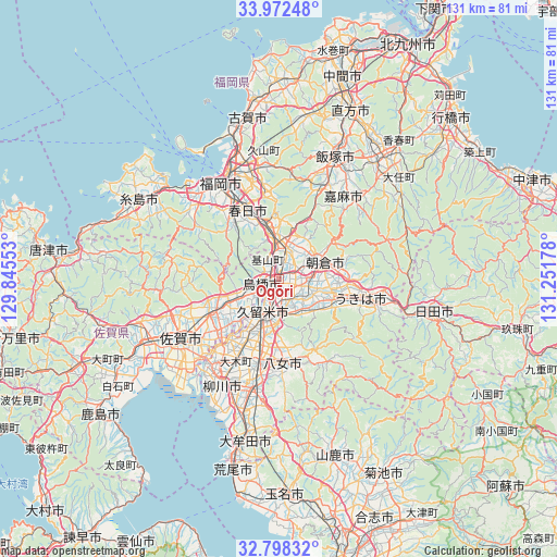
Ogōri GPS coordinates[2]
33° 23' 14.568" North, 130° 32' 55.14" East
| Map corner | latitude | longitude |
|---|---|---|
| Upper-left | 33.97248°, | 129.84553° |
| Center: | 33.38738°, | 130.54865° |
| Lower-right: | 32.79832°, | 131.25178° |
| Map W x H: | 130.6×130.6 km | = 81.2×81.2mi |
| max Lat: | 45.40944° ⇑86.8% North |
| Ogōri: | 33.38738° |
| min Lat: | ⇓13.2% South 24.34478° |
| min Long | Ogōri | max Long |
| 123° | 130.54865° | 145.575° |
| W 8.2%⇐ | ⇒91.8% E |
Elevation
Elevation of Ogōri is 16 m = 52 ft, and this is 68.6 m = 225 ft below average elevation for this country.
| Max E: |
1086 m = 3563 ft | 63.7% |
| Avg. | 84.6 m = 278 ft | |
| Ogōri | 16 m = 52 ft | |
Min E: |
-2 m = -7 ft | 36.3% |
See also: Japan elevation on elevation.city.
Geographical zone
Ogōri is located in North temperate zone (between Tropic of Cancer and the Arctic Circle). Distance of this Northern Tropic circle is 1106.4 km =687.5 mi to South.| Distance of | km | miles | from Ogōri |
|---|---|---|---|
| North Pole | 6294.7 | 3911.3 | to North |
| Arctic Circle | 3688.8 | 2292.1 | to North |
| Tropic Cancer | 1106.4 | 687.5 | to South |
| Equator | 3712.3 | 2306.7 | to South |


Nearby cities:
15 places around Ogōri: (largest is in red/bold)
• Amagi
10.4 km =6.5 mi,  70°
70°
• Asakura
16.1 km =10 mi,  79°
79°
• Chikugo
20.9 km =13 mi,  194°
194°
• Chikushino-shi
12.5 km =7.8 mi,  345°
345°
• Dazaifu
14.1 km =8.8 mi, 350°
• Kanzaki
20.6 km =12.8 mi,  249°
249°
• Kanzakimachi-kanzaki
18.4 km =11.4 mi,  241°
241°
• Kasuga
17.4 km =10.8 mi,  332°
332°
• Kurume
8.4 km =5.2 mi,  200°
200°
• Tanushimarumachi-toyoki
13.2 km =8.2 mi,  108°
108°
• Tosu
3.8 km =2.4 mi,  232°
232°
• Ukiha
19 km =11.8 mi,  100°
100°
• Umi
20.4 km =12.7 mi, 349°
• Yame
20 km =12.4 mi,  152°
152°
• Ōnojō
17.7 km =11 mi,  338°
338°
Sources, notices
• [Note1] Compared only with cities in Japan existing in our database
• [Src1] Map data: © OpenStreetMap contributors (CC-BY-SA)
• [Src2] Other city data from geonames.org with taken over terms of usage.
• [Src3] Geographical zone / Annual Mean Temperature by Robert A. Rohde @ Wikipedia
