Shima geodata
Shima (Mie) is a seat of a second-order administrative division; located in Japan in Asia/Tokyo (GMT+9) time zone. In our database, there are 767 cities with bigger population. Compared to other cities in Japan, 75.5% of cities are located further ↑North; 54.7% of cities are located further →East and 71.1% of cities have higher elevation than Shima. Note1


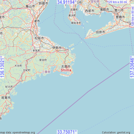
Shima GPS coordinates[2]
34° 19' 59.988" North, 136° 49' 59.988" East
| Map corner | latitude | longitude |
|---|---|---|
| Upper-left | 34.91194°, | 136.13021° |
| Center: | 34.33333°, | 136.83333° |
| Lower-right: | 33.75071°, | 137.53646° |
| Map W x H: | 129.1×129.1 km | = 80.2×80.2mi |
| max Lat: | 45.40944° ⇑75.5% North |
| Shima: | 34.33333° |
| min Lat: | ⇓24.5% South 24.34478° |
| min Long | Shima | max Long |
| 123° | 136.83333° | 145.575° |
| W 45.3%⇐ | ⇒54.7% E |
Elevation
Elevation of Shima is 11 m = 36 ft, and this is 73.6 m = 241 ft below average elevation for this country.
| Max E: |
1086 m = 3563 ft | 71.1% |
| Avg. | 84.6 m = 278 ft | |
| Shima | 11 m = 36 ft | |
Min E: |
-2 m = -7 ft | 28.9% |
See also: Japan elevation on elevation.city.
Geographical zone
Shima is located in North temperate zone (between Tropic of Cancer and the Arctic Circle). Distance of this Northern Tropic circle is 1211.6 km =752.9 mi to South.| Distance of | km | miles | from Shima |
|---|---|---|---|
| North Pole | 6189.6 | 3846 | to North |
| Arctic Circle | 3583.7 | 2226.8 | to North |
| Tropic Cancer | 1211.6 | 752.9 | to South |
| Equator | 3817.5 | 2372.1 | to South |


Nearby cities:
15 places around Shima: (largest is in red/bold)
• Handa
61.8 km =38.4 mi,  8°
8°
• Hisai-motomachi
50 km =31.1 mi,  317°
317°
• Ise
20.7 km =12.9 mi, 323°
• Ishiki
54.5 km =33.9 mi,  17°
17°
• Kawage
58.6 km =36.4 mi,  333°
333°
• Kihoku
47.8 km =29.7 mi,  253°
253°
• Matsusaka
38.5 km =23.9 mi, 315°
• Minamiise
12.4 km =7.7 mi,  278°
278°
• Nishio
62.5 km =38.8 mi, 18°
• Tahara
54.3 km =33.7 mi,  46°
46°
• Taketoyo
58 km =36 mi, 7°
• Toba
16.7 km =10.4 mi,  2°
2°
• Tokoname
61.2 km =38 mi, 1°
• Toyohama
42.8 km =26.6 mi, 12°
• Tsu
53.1 km =33 mi, 326°
Sources, notices
• [Note1] Compared only with cities in Japan existing in our database
• [Src1] Map data: © OpenStreetMap contributors (CC-BY-SA)
• [Src2] Other city data from geonames.org with taken over terms of usage.
• [Src3] Geographical zone / Annual Mean Temperature by Robert A. Rohde @ Wikipedia
