Matsusaka geodata
Matsusaka (Mie) is a seat of a second-order administrative division; located in Japan in Asia/Tokyo (GMT+9) time zone. In our database, there are 767 cities with bigger population. Compared to other cities in Japan, 70.8% of cities are located further ↑North; 58% of cities are located further →East and 86% of cities have higher elevation than Matsusaka. Note1


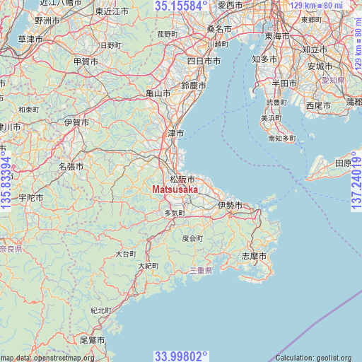
Matsusaka GPS coordinates[2]
34° 34' 44.22" North, 136° 32' 13.416" East
| Map corner | latitude | longitude |
|---|---|---|
| Upper-left | 35.15584°, | 135.83394° |
| Center: | 34.57895°, | 136.53706° |
| Lower-right: | 33.99802°, | 137.24019° |
| Map W x H: | 128.7×128.7 km | = 80×80mi |
| max Lat: | 45.40944° ⇑70.8% North |
| Matsusaka: | 34.57895° |
| min Lat: | ⇓29.2% South 24.34478° |
| min Long | Matsusaka | max Long |
| 123° | 136.53706° | 145.575° |
| W 42%⇐ | ⇒58% E |
Elevation
Elevation of Matsusaka is 6 m = 20 ft, and this is 78.6 m = 258 ft below average elevation for this country.
| Max E: |
1086 m = 3563 ft | 86% |
| Avg. | 84.6 m = 278 ft | |
| Matsusaka | 6 m = 20 ft | |
Min E: |
-2 m = -7 ft | 14% |
See also: Japan elevation on elevation.city.
Geographical zone
Matsusaka is located in North temperate zone (between Tropic of Cancer and the Arctic Circle). Distance of this Northern Tropic circle is 1238.9 km =769.8 mi to South.| Distance of | km | miles | from Matsusaka |
|---|---|---|---|
| North Pole | 6162.2 | 3829 | to North |
| Arctic Circle | 3556.4 | 2209.8 | to North |
| Tropic Cancer | 1238.9 | 769.8 | to South |
| Equator | 3844.8 | 2389 | to South |


Nearby cities:
15 places around Matsusaka: (largest is in red/bold)
• Hisai-motomachi
11.7 km =7.3 mi,  326°
326°
• Iga
41.8 km =26 mi,  298°
298°
• Ise
18.3 km =11.4 mi,  125°
125°
• Kameyama
31.2 km =19.4 mi,  345°
345°
• Kasado
34.7 km =21.6 mi,  359°
359°
• Kawage
25.1 km =15.6 mi,  1°
1°
• Minamiise
29.5 km =18.3 mi,  149°
149°
• Nabari
41.7 km =25.9 mi,  275°
275°
• Shima
38.5 km =23.9 mi,  135°
135°
• Suzuka
34.1 km =21.2 mi,  7°
7°
• Toba
29.9 km =18.6 mi,  110°
110°
• Toyohama
39.1 km =24.3 mi,  68°
68°
• Tsu
17.3 km =10.7 mi, 353°
• Ueno-ebisumachi
42.2 km =26.2 mi, 298°
• Yokkaichi
43.7 km =27.2 mi, 9°
Sources, notices
• [Note1] Compared only with cities in Japan existing in our database
• [Src1] Map data: © OpenStreetMap contributors (CC-BY-SA)
• [Src2] Other city data from geonames.org with taken over terms of usage.
• [Src3] Geographical zone / Annual Mean Temperature by Robert A. Rohde @ Wikipedia
